IMAGES TAKEN NEAR TO
Fotherby, LOUTH, LN11 0UN
Introduction
This page details the photographs taken nearby to LN11 0UN by members of the Geograph project.
The Geograph project started in 2005 with the aim of publishing, organising and preserving representative images for every square kilometre of Great Britain, Ireland and the Isle of Man.

There are currently over 7.5m images from over14,400 individuals and you can help contribute to the project by visiting https://www.geograph.org.uk
Image Map (Loading...)


Getting Data...Please wait
Leaflet Map data © OpenStreetMap
Images are licensed for reuse under creativecommons.org/licenses/by-sa/2.0
Notes
- Clicking on the map will re-center to the selected point.
- The higher the marker number, the further away the image location is from the centre of the postcode.
Image Listing (14 Images Found)
Images are licensed for reuse under creativecommons.org/licenses/by-sa/2.0
Image
Details
Distance
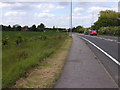
2
Turn off for Fotherby on the A16
Louth Road heading south.
Image: © JThomas
Taken: 11 Sep 2015
0.04 miles
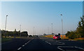
3
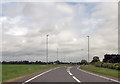
A16 Fotherby by-pass
Looking south the road forms the by-pass immediately after the junction. Interestingly, the A16 was officially "de-trunked" in 2002.
Image: © John Beal
Taken: 22 May 2007
0.05 miles
4
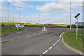
Junction of Louth road with the A16
Left for Louth, right to Grimsby.
Image: © J. Hannan-Briggs
Taken: 4 May 2015
0.05 miles
5
Old road and cottage
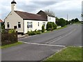
A view of a small "branch" of the old A16 near Fotherby, now being used as an access road for this lovely cottage and also a farm to the rear of the photographer.
Image: © John Beal
Taken: 22 May 2007
0.06 miles
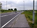
6
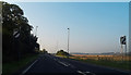
Louth Road (A16)
Heading south near Old Mill Farm.
Image: © JThomas
Taken: 11 Sep 2015
0.07 miles
7
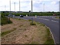
New road junction
The A16 trunk road by-pass opened in 2003 from when this became the entrance to Fotherby from the north.
Image: © John Beal
Taken: 22 May 2007
0.07 miles
9
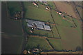
Garden centre and ridge and furrow field north of Fotherby: aerial 2015
Image: © Chris
Taken: 27 Dec 2015
0.15 miles
10
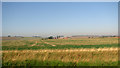
Cultivated fields south of Utterby
Grange Farm can be seen in the background (in adjacent grid square).
Image: © Evelyn Simak
Taken: 29 Sep 2011
0.16 miles