IMAGES TAKEN NEAR TO
Allenby Close, LOUTH, LN11 0UL
Introduction
This page details the photographs taken nearby to Allenby Close, LN11 0UL by members of the Geograph project.
The Geograph project started in 2005 with the aim of publishing, organising and preserving representative images for every square kilometre of Great Britain, Ireland and the Isle of Man.

There are currently over 7.5m images from over14,400 individuals and you can help contribute to the project by visiting https://www.geograph.org.uk
Image Map (Loading...)


Getting Data...Please wait
Leaflet Map data © OpenStreetMap
Images are licensed for reuse under creativecommons.org/licenses/by-sa/2.0
Notes
- Clicking on the map will re-center to the selected point.
- The higher the marker number, the further away the image location is from the centre of the postcode.
Image Listing (75 Images Found)
Images are licensed for reuse under creativecommons.org/licenses/by-sa/2.0
Image
Details
Distance

5

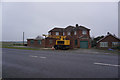
Large house, Fotherby
To the left of the main building is Allenby Crescent. There are extra buildings that indicate there was additional activity at this property, some kind of fire station or provision for providing water for some purpose is evident.
Image: © John Beal
Taken: 22 May 2007
0.09 miles
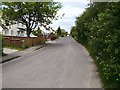
7

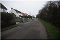
A bend in the Crescent
Allenby Crescent looking back towards the church.
Image: © John Beal
Taken: 22 May 2007
0.10 miles
8
Around the crescent
Northward view of Allenby Crescent.
Image: © John Beal
Taken: 22 May 2007
0.10 miles
9
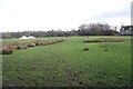
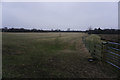
Moated platform at Fotherby (2)
On this shot the "moated platform" is on the left.
See Image, in which you are looking from right to left across what seems, on the right, to be a moated site. On the left of the aerial shot are two parallel linear depressions.
The Heritage Environment Record relates to this area, but refers only to "fishponds":
https://www.heritagegateway.org.uk/Gateway/Results_Single.aspx?uid=af841456-659c-4f64-8b04-069e869e6e06&resourceID=19191
"Sunken Field" Image also shows the "moated site".
Image: © Chris
Taken: 15 Jan 2023
0.10 miles
10
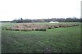
Moated platform at Fotherby (1)
See Image, in which you are looking from right to left across what seems, on the right, to be a moated site. On the left of the aerial shot are two parallel linear depressions.
The Heritage Environment Record relates to this area, but refers only to "fishponds":
https://www.heritagegateway.org.uk/Gateway/Results_Single.aspx?uid=af841456-659c-4f64-8b04-069e869e6e06&resourceID=19191
"Sunken Field" Image also shows the "moated site".
Image: © Chris
Taken: 15 Jan 2023
0.10 miles