IMAGES TAKEN NEAR TO
Belvoir Court, LOUTH, LN11 0UD
Introduction
This page details the photographs taken nearby to Belvoir Court, LN11 0UD by members of the Geograph project.
The Geograph project started in 2005 with the aim of publishing, organising and preserving representative images for every square kilometre of Great Britain, Ireland and the Isle of Man.

There are currently over 7.5m images from over14,400 individuals and you can help contribute to the project by visiting https://www.geograph.org.uk
Image Map (Loading...)


Getting Data...Please wait
Leaflet Map data © OpenStreetMap
Images are licensed for reuse under creativecommons.org/licenses/by-sa/2.0
Notes
- Clicking on the map will re-center to the selected point.
- The higher the marker number, the further away the image location is from the centre of the postcode.
Image Listing (14 Images Found)
Images are licensed for reuse under creativecommons.org/licenses/by-sa/2.0
Image
Details
Distance
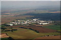
1
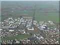
Former railway, and Fairfield Industrial Estate, Louth: aerial 2022
Image: © Simon Tomson
Taken: 25 Nov 2022
0.01 miles
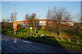
2
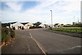
Fairfield Industrial Estate
Light industrial units north of Louth
Image: © Richard Croft
Taken: 19 Nov 2008
0.08 miles
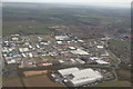
3
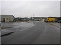
Fairfield Industrial Estate South
The southern part of this estate is more developed than the northern end.
Image: © Michael Patterson
Taken: 8 Mar 2006
0.10 miles
4
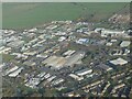
Fairfield Industrial Estate, Louth: aerial 2022
Image: © Chris
Taken: 25 Nov 2022
0.13 miles
7
Fairfield Road Industrial Estate, Louth: aerial 2015
Image: © Chris
Taken: 20 Oct 2015
0.19 miles
8
Fairfield Road Industrial Estate, Louth: aerial 2018
Image: © Chris
Taken: 13 Mar 2018
0.20 miles
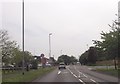
9
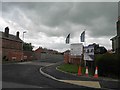
Dales way, new housing development off Brackenborough road, Louth
Image: © Steve Fareham
Taken: 2 Jun 2013
0.21 miles