IMAGES TAKEN NEAR TO
Utterby, LOUTH, LN11 0TN
Introduction
This page details the photographs taken nearby to LN11 0TN by members of the Geograph project.
The Geograph project started in 2005 with the aim of publishing, organising and preserving representative images for every square kilometre of Great Britain, Ireland and the Isle of Man.

There are currently over 7.5m images from over14,400 individuals and you can help contribute to the project by visiting https://www.geograph.org.uk
Image Map (Loading...)


Getting Data...Please wait
Leaflet Map data © OpenStreetMap
Images are licensed for reuse under creativecommons.org/licenses/by-sa/2.0
Notes
- Clicking on the map will re-center to the selected point.
- The higher the marker number, the further away the image location is from the centre of the postcode.
Image Listing (12 Images Found)
Images are licensed for reuse under creativecommons.org/licenses/by-sa/2.0
Image
Details
Distance
1
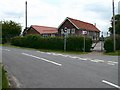
Utterby Primary School
As seen from the road junction at the end of Pear Tree Lane.
Image: © John Beal
Taken: 24 May 2007
0.01 miles
2
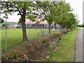
Playground, Utterby Primary School
The school is situated at the end of Pear Tree Lane.
Image: © John Beal
Taken: 24 May 2007
0.02 miles
3
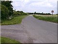
Lane to Ludborough Vale
The line of trees on the right is the start of the Vale with extends back to the main A18.
Image: © John Beal
Taken: 24 May 2007
0.03 miles
4
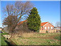
Utterby Primary School
The school stands alone in this farmland area.
Image: © Stephen Horncastle
Taken: 27 Jan 2007
0.03 miles
5
Entrance to The Vale Farm
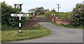
The main farm buildings can also be seen, and they are located in the next square TF2894. The older, simple and well made direction sign makes a pleasant change to the rather austere modern versions.
Image: © John Beal
Taken: 24 May 2007
0.03 miles
6
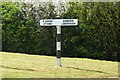
Direction Sign ? Signpost on Barton Street, North Ormsby
Located on the west side of the junction of Barton Street and Pear Tree Lane, in North Ormsby parish. 2 arms but no finial. See also https://www.geograph.org.uk/photo/460927.
Milestone Society National ID: LI_TF2994
Image: © A Riley
Taken: 24 Apr 2022
0.03 miles
7
The tail end of Pear Tree Lane
This area has been extensively remodelled. This used to be part of Pear Tree Lane in the adjacent squares to the east, but now the Ludborough bypass cuts through it, with a staggered junction created.
The section of Pear Tree Lane in the picture is now used mainly as a convenient short-cut to the A18 west of Ludborough, though there is also a primary school on the bottom corner.
The Lincolnshire Wolds rise in the background.
Image: © Chris
Taken: 2 Dec 2012
0.03 miles
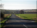
8

Lane near Ludborough
This well-maintained lane is near the local village school.
Image: © John Martin
Taken: 27 Jun 2007
0.09 miles
9
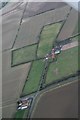
Ridge and furrow and old enclosure boundaries, Ludborough Vale: aerial 2018
Vale Farm.
Image: © Chris
Taken: 22 Dec 2018
0.14 miles
10

Oilseed rape near North Ormesby
This is what is meant by monoculture.
Image: © Jonathan Thacker
Taken: 27 Apr 2012
0.15 miles