IMAGES TAKEN NEAR TO
North End, LOUTH, LN11 0QH
Introduction
This page details the photographs taken nearby to North End, LN11 0QH by members of the Geograph project.
The Geograph project started in 2005 with the aim of publishing, organising and preserving representative images for every square kilometre of Great Britain, Ireland and the Isle of Man.

There are currently over 7.5m images from over14,400 individuals and you can help contribute to the project by visiting https://www.geograph.org.uk
Image Map
Images are licensed for reuse under creativecommons.org/licenses/by-sa/2.0
Notes
- Clicking on the map will re-center to the selected point.
- The higher the marker number, the further away the image location is from the centre of the postcode.
Image Listing (27 Images Found)
Images are licensed for reuse under creativecommons.org/licenses/by-sa/2.0
Image
Details
Distance
1
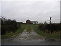
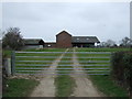
Newholme Farm
The farm house itself is set off to the left of these farm buildings.
Image: © Michael Patterson
Taken: 8 Mar 2006
0.08 miles
2
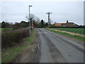
Minor road heading south east by Newholme Farm
Towards North End.
Image: © JThomas
Taken: 21 Mar 2015
0.08 miles
3
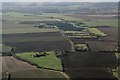
Earthworks and solar installation at Yarburgh: aerial 2017
Looking up Westfield Road.
This is an area rich in history - see Image
Image: © Chris
Taken: 29 Jan 2017
0.09 miles
4
Welcome to Newholme
This is what lies in wait for walkers on this path.
Image: © Chris
Taken: 14 Feb 2013
0.10 miles
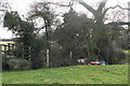
5
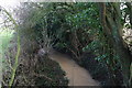
Secluded spot behind Newholme
From the footpath bridge (next to the gas gun in Image).
The stream merges with Yarburgh Beck to become the Black Dike.
Level is high following recent rain.
Image: © Chris
Taken: 14 Feb 2013
0.11 miles
7

Newholme Farm - brickwork
Detail. Some interesting brickwork on one of the farm buildings
Image: © Chris
Taken: 15 Jul 2012
0.12 miles
8

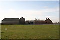
Newholme Farm, Yarburgh
From the Alvingham Road.
Image: © Chris
Taken: 15 Jul 2012
0.12 miles
9
The back of Newholme
From the public footpath across the field.
Image: © Chris
Taken: 14 Feb 2013
0.13 miles
10
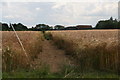
Yarburgh footpath, Newholme Farm
The farm is top right above the field of ripening barley. The footpath is clearly marked over this stretch, though as it approaches Northolme Farm (chimney just visible left of centre) it passes through beds of thistles which have been treated with weedkiller, causing them to make abnormal growth and knot together. The Council says this is a "Priority 2 footpath",and they will clear it by the end of the year!
Image: © Chris
Taken: 15 Jul 2012
0.13 miles