IMAGES TAKEN NEAR TO
High Bridge Road, LOUTH, LN11 0QE
Introduction
This page details the photographs taken nearby to High Bridge Road, LN11 0QE by members of the Geograph project.
The Geograph project started in 2005 with the aim of publishing, organising and preserving representative images for every square kilometre of Great Britain, Ireland and the Isle of Man.

There are currently over 7.5m images from over14,400 individuals and you can help contribute to the project by visiting https://www.geograph.org.uk
Image Map (Loading...)


Getting Data...Please wait
Leaflet Map data © OpenStreetMap
Images are licensed for reuse under creativecommons.org/licenses/by-sa/2.0
Notes
- Clicking on the map will re-center to the selected point.
- The higher the marker number, the further away the image location is from the centre of the postcode.
Image Listing (39 Images Found)
Images are licensed for reuse under creativecommons.org/licenses/by-sa/2.0
Image
Details
Distance
1
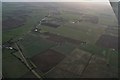
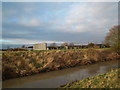
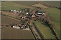
Highbridge, Alvingham, on Louth Canal: aerial 2018 (3)
Image: © Chris
Taken: 7 Feb 2018
0.03 miles
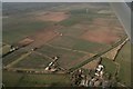
2
Highbridge, Alvingham, on Louth Canal: aerial 2018 (2)
Image: © Chris
Taken: 7 Feb 2018
0.03 miles
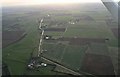
3
Highbridge, Alvingham, on Louth Canal: aerial 2018 (4)
Cross Poplar Grove and America Farm to Yarburgh.
Image: © Chris
Taken: 17 Feb 2018
0.04 miles
4
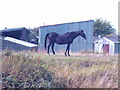
Old swayback thoroughbred mare at Highbridge
Looks as if it has born all the troubles of the world on its back, though more likely that it has had too many foals.
View across the Louth Canal from the tow path.
Image: © Chris
Taken: 28 Jul 2008
0.06 miles
5
View across the disused canal at Highbridge
Same farm as in Image
Image: © Chris
Taken: 25 Dec 2012
0.07 miles
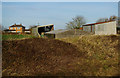
7
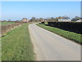
High Bridge Road approaching High Bridge House
Looking north-eastward.
Image: © Peter Wood
Taken: 27 Feb 2019
0.07 miles
8
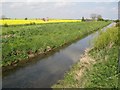
Louth Canal and rapeseed
An unusual splash of red livens the view of another rapeseed field as a crop-sprayer makes its way parallel to the canal.
Image: © Jonathan Wilkins
Taken: 23 Apr 2014
0.08 miles
9
Alvingham High Bridge, disused Louth Navigation: aerial 2017
Image: © Chris
Taken: 5 Jan 2017
0.08 miles
10
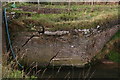
Louth Navigation at Highbridge, Alvingham: the cracks are showing
As you can see, the wall of the disused canal, adjoining the concrete road bridge, is not long for this world, the biggest cracks being recent.
An Environment Agency employee said it would no doubt collapse and then, at that point, the EA would come and clear the mess away and probably replace with wire cages of rocks as at the straight-sided lock nearby.
There is a cow drinker just behind the wall (top left) so it won't be helping that the cows are gathering here, so forcing the wall outwards.
Image: © Chris
Taken: 11 Nov 2015
0.08 miles