IMAGES TAKEN NEAR TO
Church Lane, LOUTH, LN11 0PY
Introduction
This page details the photographs taken nearby to Church Lane, LN11 0PY by members of the Geograph project.
The Geograph project started in 2005 with the aim of publishing, organising and preserving representative images for every square kilometre of Great Britain, Ireland and the Isle of Man.

There are currently over 7.5m images from over14,400 individuals and you can help contribute to the project by visiting https://www.geograph.org.uk
Image Map (Loading...)


Getting Data...Please wait
Leaflet Map data © OpenStreetMap
Images are licensed for reuse under creativecommons.org/licenses/by-sa/2.0
Notes
- Clicking on the map will re-center to the selected point.
- The higher the marker number, the further away the image location is from the centre of the postcode.
Image Listing (89 Images Found)
Images are licensed for reuse under creativecommons.org/licenses/by-sa/2.0
Image
Details
Distance
1
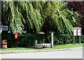
Village stocks, Alvingham
An eclectic group of street furniture at the heart of the village.
Image: © Simon Huguet
Taken: 3 Sep 2008
0.04 miles
2
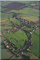
Alvingham: aerial 2015
For details of medieval or post medieval village see: http://www.pastscape.org.uk/hob.aspx?hob_id=1060915&sort=2&rational=m&recordsperpage=10&maplat=53.40202552&maplong=0.04814321&mapisa=1000&mapist=os&mapilo=0.0481&mapila=53.4020&mapiloe=e&mapilan=n&mapios=TF361914&mapigrn=391450&mapigre=536150&mapipc=#aRt
For Gilbertine Priory see http://www.pastscape.org.uk/hob.aspx?hob_id=354728&sort=2&rational=m&recordsperpage=10&maplat=53.40202552&maplong=0.04814321&mapisa=1000&mapist=os&mapilo=0.0481&mapila=53.4020&mapiloe=e&mapilan=n&mapios=TF361914&mapigrn=391450&mapigre=536150&mapipc=#aRt
For history see also village website: http://www.alvinghamvillage.co.uk/id3.html
Image: © Chris
Taken: 27 Dec 2015
0.05 miles
3

Scarecrow in the church doorway.
Between the old methodist chapel building and the former post office.
This was a scarecrow competition with a difference!
Image: © Chris
Taken: 30 Aug 2009
0.07 miles
4
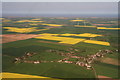
Alvingham to the sea: aerial 2014
20 turbines of Conisholme windfarm and solar park behind. Another turbine centre left. So many turbines!
Louth Navigation (disused) runs across from the right, past the two churches.
Highbridge Road, up the centre, leads to the Navigation at High Bridge, then continues as a bridleway past the (right side of) the windfarm to Conisholme.
Image: © Chris
Taken: 3 May 2014
0.07 miles
5
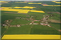
Alvingham: aerial 2014
Looking eastwards. 20 turbines of Conisholme windfarm and solar park behind.
Louth Navigation (disused) runs across from bottom right, past the two churches.
Highbridge Road, up the centre, leads to the Navigation at High Bridge, then continues as a bridleway past the (right side of) the windfarm to Conisholme.
Image: © Chris
Taken: 3 May 2014
0.07 miles
6

White Barn Farm
On the corner as you leave the village to the south.
Image: © Chris
Taken: 15 Jul 2012
0.09 miles
7
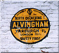
Old circular AA Sign on Alvingham Road, Alvingham
Old AA Sign set on the southeast facing gable end of a barn at White Barn Farm on Alvingham Road, Alvingham, 4 miles northeast of Louth. Alvingham parish.
This is the circular, village name on black band, no Motor Union symbol or name type, dating from 1923, and showing distances North Cockering 1 Yarburgh 1½ London 151½.
There were five series of AA signs, mostly dating from 1923 and made by Francis & Co / Franco in Deptford, London. The village name and distance to London were displayed.
See also https://www.flickr.com/photos/8701617@N07/34520059393 , https://www.flickr.com/photos/davidwooler/15799348226 and https://www.flickr.com/photos/kitmasterbloke/51377313242.
Milestone Society National ID: LI-ALVING
Image: © Milestone Society
Taken: Unknown
0.10 miles
8
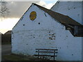
Old AA sign
The AA village sign high up on the end of the barn at White Barn Farm. This is at the SW end of the village at the junction of the road into the village and the one northwards towards Yarburgh.
Image: © Chris Minto
Taken: 6 Mar 2022
0.10 miles
9

Stream passing White Barn Farm
Looking down the Louth Road. The stream spends much of its life underground, but here puts in a brief appearance.
Image: © Chris
Taken: 15 Jul 2012
0.10 miles
