IMAGES TAKEN NEAR TO
Fire Beacon Lane, LOUTH, LN11 0PA
Introduction
This page details the photographs taken nearby to Fire Beacon Lane, LN11 0PA by members of the Geograph project.
The Geograph project started in 2005 with the aim of publishing, organising and preserving representative images for every square kilometre of Great Britain, Ireland and the Isle of Man.

There are currently over 7.5m images from over14,400 individuals and you can help contribute to the project by visiting https://www.geograph.org.uk
Image Map
Images are licensed for reuse under creativecommons.org/licenses/by-sa/2.0
Notes
- Clicking on the map will re-center to the selected point.
- The higher the marker number, the further away the image location is from the centre of the postcode.
Image Listing (48 Images Found)
Images are licensed for reuse under creativecommons.org/licenses/by-sa/2.0
Image
Details
Distance
1

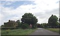
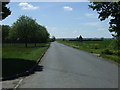
Bend ahead on lane near Covenham water treatment works
Image: © Steve Fareham
Taken: 18 Apr 2015
0.01 miles
2
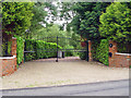
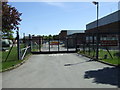
The Gateway to Beacon Lodge
Beacon Lodge was difficult to photograph owing to access restrictions, so herewith the gateway.
Image: © Peter Church
Taken: 21 Jun 2008
0.03 miles
3
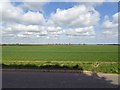
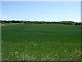
Flat Lincolnshire farmland near Covenham reservoir
Image: © Steve Fareham
Taken: 18 Apr 2015
0.05 miles

7
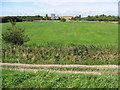
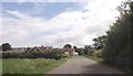
View To Covenham Reservoir Buildings
View across the field from Louth Canal to the buildings at Covenham Reservoir.
Image: © Stephen Horncastle
Taken: 30 Aug 2007
0.08 miles