IMAGES TAKEN NEAR TO
Yarburgh, LOUTH, LN11 0NU
Introduction
This page details the photographs taken nearby to LN11 0NU by members of the Geograph project.
The Geograph project started in 2005 with the aim of publishing, organising and preserving representative images for every square kilometre of Great Britain, Ireland and the Isle of Man.

There are currently over 7.5m images from over14,400 individuals and you can help contribute to the project by visiting https://www.geograph.org.uk
Image Map (Loading...)


Getting Data...Please wait
Leaflet Map data © OpenStreetMap
Images are licensed for reuse under creativecommons.org/licenses/by-sa/2.0
Notes
- Clicking on the map will re-center to the selected point.
- The higher the marker number, the further away the image location is from the centre of the postcode.
Image Listing (19 Images Found)
Images are licensed for reuse under creativecommons.org/licenses/by-sa/2.0
Image
Details
Distance
1
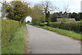
Westfield Road
Little Beck Farm is on the right.
Image: © J. Hannan-Briggs
Taken: 4 May 2015
0.01 miles
2
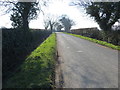
Hedge-lined Westfield Road near to Grove and Little Beck Farms
Looking south-westward.
Image: © Peter Wood
Taken: 27 Feb 2019
0.06 miles
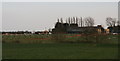
3
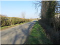
Hedge-lined Westfield Road at Grove and Little Beck Farms
Looking north-eastward.
Image: © Peter Wood
Taken: 27 Feb 2019
0.07 miles
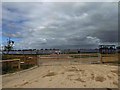
5
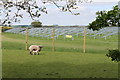
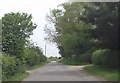
Installation of Solar Panels
Near Grove Farm, Westfield Road.
Image: © J. Hannan-Briggs
Taken: 4 May 2015
0.10 miles
6
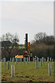
Yarburgh: solar "farm"? You won't even notice it...
Driving in the supports for the photovoltaic panels.
Image: © Chris
Taken: 14 Apr 2015
0.10 miles
7
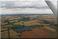
Yarburgh solar "farm": aerial July 2015
Covenham Reservoir in the distance, with the Humber Estuary beyond.
For earlier shot see Image
Yarburgh, already blighted by 21 wind turbines has now been subjected to further industrialisation in the name of the so-called "green energy".
Like the turbines, this installation is visible from all four sides: Westfield Road across the bottom, Lincoln Lane across the top, footpath from Yarburgh to Westfield Road right, and Brackenborough Road (leading to Little Grimsby and Covenham) up the left side.
Image: © Chris
Taken: 23 Jul 2015
0.11 miles
8
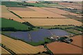
Solar farm at Yarburgh: aerial 2015
At Grove Farm is now this massive 35 acre solar energy site. Yarburgh area seems to have been targeted by renewable energy developers: it already has no less than 21 wind turbines on the east side.
See also Image, Image and Image
Image: © Chris
Taken: 23 Jul 2015
0.12 miles
10
Yarburgh: solar "farm"? You won't even notice it...
This is a view from the bridleway known as Lincoln Lane. It wouldn't all fit in the shot. Another blot on the local landscape, to go with the 21 wind turbines.
Image: © Chris
Taken: 14 Apr 2015
0.12 miles