IMAGES TAKEN NEAR TO
Staines Way, LOUTH, LN11 0DF
Introduction
This page details the photographs taken nearby to Staines Way, LN11 0DF by members of the Geograph project.
The Geograph project started in 2005 with the aim of publishing, organising and preserving representative images for every square kilometre of Great Britain, Ireland and the Isle of Man.

There are currently over 7.5m images from over14,400 individuals and you can help contribute to the project by visiting https://www.geograph.org.uk
Image Map (Loading...)


Getting Data...Please wait
Leaflet Map data © OpenStreetMap
Images are licensed for reuse under creativecommons.org/licenses/by-sa/2.0
Notes
- Clicking on the map will re-center to the selected point.
- The higher the marker number, the further away the image location is from the centre of the postcode.
Image Listing (34 Images Found)
Images are licensed for reuse under creativecommons.org/licenses/by-sa/2.0
Image
Details
Distance
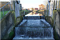
4

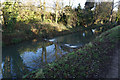
The Tilting Weir, Louth Canal
This is the site of the Top Lock on the Louth Navigation (disused), photographed during the 2007 floods (June - there was another in July!)
Image: © Chris
Taken: 15 Jun 2007
0.12 miles
5
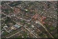
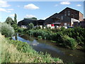
Riverhead, Louth Navigation, after heavy rain: aerial 2018 (2)
Image: © Chris
Taken: 13 Mar 2018
0.12 miles
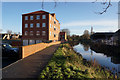
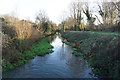
7
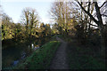
The Louth Canal, River Lud
Heading towards Keddington Corner.
Image: © Ian S
Taken: 18 Dec 2017
0.12 miles