IMAGES TAKEN NEAR TO
Tattershall Road, WOODHALL SPA, LN10 6YN
Introduction
This page details the photographs taken nearby to Tattershall Road, LN10 6YN by members of the Geograph project.
The Geograph project started in 2005 with the aim of publishing, organising and preserving representative images for every square kilometre of Great Britain, Ireland and the Isle of Man.

There are currently over 7.5m images from over14,400 individuals and you can help contribute to the project by visiting https://www.geograph.org.uk
Image Map (Loading...)


Getting Data...Please wait
Leaflet Map data © OpenStreetMap
Images are licensed for reuse under creativecommons.org/licenses/by-sa/2.0
Notes
- Clicking on the map will re-center to the selected point.
- The higher the marker number, the further away the image location is from the centre of the postcode.
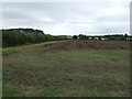
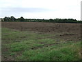
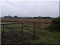
Image Listing (8 Images Found)
Images are licensed for reuse under creativecommons.org/licenses/by-sa/2.0
Image
Details
Distance
1
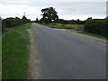
Minor road heading south
Towards Coningsby.
Image: © JThomas
Taken: 10 Aug 2013
0.03 miles
5
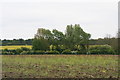
Willows on the bank of River Bain near Kirkby on Bain
Image: © Chris
Taken: 9 May 2017
0.21 miles
6
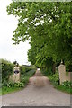
Leafy driveway to Riverslea Farm
Kirkby on Bain.
Image: © Chris
Taken: 9 May 2017
0.21 miles
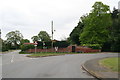
8
Multi-service centre, Kirkby on Bain
Transport, postal, library and information services in one spot
Image: © Tim Heaton
Taken: 25 Mar 2016
0.25 miles