IMAGES TAKEN NEAR TO
Tattershall Road, WOODHALL SPA, LN10 6TT
Introduction
This page details the photographs taken nearby to Tattershall Road, LN10 6TT by members of the Geograph project.
The Geograph project started in 2005 with the aim of publishing, organising and preserving representative images for every square kilometre of Great Britain, Ireland and the Isle of Man.

There are currently over 7.5m images from over14,400 individuals and you can help contribute to the project by visiting https://www.geograph.org.uk
Image Map (113 Images)


Getting Data...Please wait
Leaflet Map data © OpenStreetMap
Images are licensed for reuse under creativecommons.org/licenses/by-sa/2.0
Notes
- Clicking on the map will re-center to the selected point.
- The higher the marker number, the further away the image location is from the centre of the postcode.
Image Listing (113 Images Found)
Images are licensed for reuse under creativecommons.org/licenses/by-sa/2.0
Image
Details
Distance
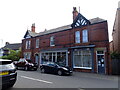
2
Budgens Supermarket, Woodhall Spa
Budgens Stores Ltd., Tattershall Road, Woodhall Spa, LN10 6TT
Image: © David Wright
Taken: 8 Sep 2007
0.02 miles
5
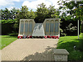
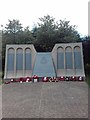
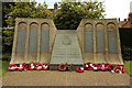
The Dam Busters Memorial in the form of a breached dam.
Woodhall Spa was built as a satellite airfield for nearby RAF Coningsby. During January 1944 617 Squadron relocated to Woodhall and remained at this airfield until the end of the war. From here 617 Squadron went on to drop the Tallboy and Grandslam bombs and to sink the Tirpitz. The last operation by 617 Squadron was on April 25th 1945 against Berchtesgaden.
All 617 squadron raids are commemorated on the memorial as well as the names of squadron aircrew who lost their lives in the Second World War. Their names are on the first http://www.geograph.org.uk/photo/5798374 and third http://www.geograph.org.uk/photo/5798371 elements of the memorial.
Image: © Adrian S Pye
Taken: 5 Jun 2018
0.05 miles
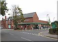
7
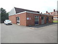
Woodhall Spa Telephone Exchange
Situated in Clarence Road, this redbrick building is of a design common in the United Kingdom and has the code SLWSP. It provides telephone and broadband services to 2,340 residential and 158 non-residential premises in Woodhall Spa and the surrounding area including Kirkby-on-Bain, Kirkstead, Martin Dales, Roughton Moor and Stixwould. Two red notices and a white BT warning notice can be seen on this TE. The numbering range of this TE is (01526) 35xxxx, the (01526) referring to the Martin group of eight TEs, and its postcode is LN10 6TZ.
Image: © David Hillas
Taken: 17 Jul 2019
0.05 miles
8
Dambusters Memorial
Memorial to the men of 617 (Dambusters) Squadron in Royal Square in Woodhall Spa, erected in 1987 on the site of the Royal Hydro Hotel and the Winter Gardens, destroyed by a bomb in 1943.
Image: © Richard Croft
Taken: 18 Jun 2014
0.06 miles
9
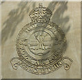
617 Squadron badge
Famous badge of 617 Squadron - The Dambusters, on the memorial in Royal Square http://www.geograph.org.uk/photo/4307729
The motto 'Apres moi le deluge' is attributed to King Louis XV of France, meaning 'after me the deluge'
Image: © Richard Croft
Taken: 18 Jun 2014
0.06 miles
10
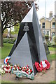
New Dambusters 617 Squadron memorial
Unveiled in May 2013 and said to symbolise the Vulcan and Tornados flown by the Squadron, the new memorial was designed by local artist Sylvia Waugh and carved by stonemasons Steve and Leon Andrews from Heighington.
Image: © J.Hannan-Briggs
Taken: 1 Jun 2013
0.06 miles