IMAGES TAKEN NEAR TO
Llangwyllog, LLANGEFNI, LL77 8UX
Introduction
This page details the photographs taken nearby to LL77 8UX by members of the Geograph project.
The Geograph project started in 2005 with the aim of publishing, organising and preserving representative images for every square kilometre of Great Britain, Ireland and the Isle of Man.

There are currently over 7.5m images from over14,400 individuals and you can help contribute to the project by visiting https://www.geograph.org.uk
Image Map (Loading...)


Getting Data...Please wait
Leaflet Map data © OpenStreetMap
Images are licensed for reuse under creativecommons.org/licenses/by-sa/2.0
Notes
- Clicking on the map will re-center to the selected point.
- The higher the marker number, the further away the image location is from the centre of the postcode.
Image Listing (6 Images Found)
Images are licensed for reuse under creativecommons.org/licenses/by-sa/2.0
Image
Details
Distance
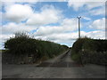
2
Private lane linking Tre-Ysgawen Hall and associated farms with the B5111 near Llangwyllog Church
Image: © Eric Jones
Taken: 10 Jul 2009
0.14 miles
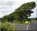
4

The B5111 north of the turnoff for the hamlet of Llangwyllog
Image: © Eric Jones
Taken: 10 Jul 2009
0.20 miles
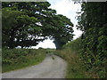
5
The turnoff on the B5111 for St Cwyllog Church, Llangwyllog
Image: © Eric Jones
Taken: 10 Jul 2009
0.24 miles
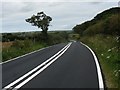
6
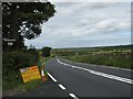
Newly refurbished section of the B5111 at Llangwyllog
Image: © Eric Jones
Taken: 10 Jul 2009
0.24 miles