IMAGES TAKEN NEAR TO
LLANGEFNI, LL77 7YF
Introduction
This page details the photographs taken nearby to LL77 7YF by members of the Geograph project.
The Geograph project started in 2005 with the aim of publishing, organising and preserving representative images for every square kilometre of Great Britain, Ireland and the Isle of Man.

There are currently over 7.5m images from over14,400 individuals and you can help contribute to the project by visiting https://www.geograph.org.uk
Image Map (Loading...)


Getting Data...Please wait
Leaflet Map data © OpenStreetMap
Images are licensed for reuse under creativecommons.org/licenses/by-sa/2.0
Notes
- Clicking on the map will re-center to the selected point.
- The higher the marker number, the further away the image location is from the centre of the postcode.
Image Listing (18 Images Found)
Images are licensed for reuse under creativecommons.org/licenses/by-sa/2.0
Image
Details
Distance
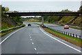
1
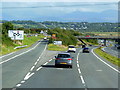
The A55 North Wales Expressway
At Junction 6.
Image: © Ian S
Taken: 28 Aug 2014
0.10 miles
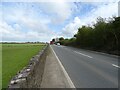
2
A55 North Wales Expressway towards Holyhead
Image: © JThomas
Taken: 16 Apr 2024
0.10 miles
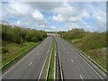
4
A pretty empty A55 at 10.00hrs on a Monday morning
Image: © Eric Jones
Taken: 14 Apr 2008
0.12 miles
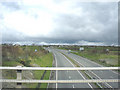
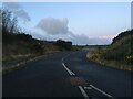
7
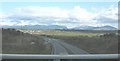
View south along the A55 Expressway with Snowdonia in the background
Image: © Eric Jones
Taken: 14 Apr 2008
0.15 miles
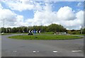
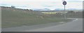
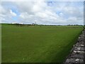
10
Undeveloped roundabout exit near Llangefni
Image: © Steven Brown
Taken: 20 Nov 2022
0.15 miles