IMAGES TAKEN NEAR TO
Capel Coch, LLANGEFNI, LL77 7UT
Introduction
This page details the photographs taken nearby to LL77 7UT by members of the Geograph project.
The Geograph project started in 2005 with the aim of publishing, organising and preserving representative images for every square kilometre of Great Britain, Ireland and the Isle of Man.

There are currently over 7.5m images from over14,400 individuals and you can help contribute to the project by visiting https://www.geograph.org.uk
Image Map
Images are licensed for reuse under creativecommons.org/licenses/by-sa/2.0
Notes
- Clicking on the map will re-center to the selected point.
- The higher the marker number, the further away the image location is from the centre of the postcode.
Image Listing (4 Images Found)
Images are licensed for reuse under creativecommons.org/licenses/by-sa/2.0
Image
Details
Distance
1
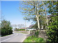
New bungalows on the northern outskirts of Capel Coch
In recent years Capel Coch has increasingly developed into a commuter village. This has led to a steady growth in the number of new houses. These, however, have tended to be individual up-market houses and bungalows. There are no private housing estates in the village.
Image: © Eric Jones
Taken: 1 May 2007
0.14 miles
2
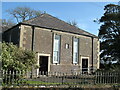
Capel llwyd at Capel Coch
There appears to be a mix up of colours at Capel Coch as the only chapel I could see was grey.
Image: © Gordon Hatton
Taken: 21 Sep 2020
0.23 miles
3
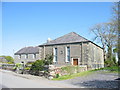
Ty Capel a Capel Coch
Capel Coch 'red chapel' and chapel house.
Image: © Eric Jones
Taken: 1 May 2007
0.23 miles
4
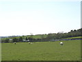
Grazing sheep in field besides a dammed stream
Image: © Eric Jones
Taken: 1 May 2007
0.24 miles