IMAGES TAKEN NEAR TO
Tregaian, LLANGEFNI, LL77 7UP
Introduction
This page details the photographs taken nearby to LL77 7UP by members of the Geograph project.
The Geograph project started in 2005 with the aim of publishing, organising and preserving representative images for every square kilometre of Great Britain, Ireland and the Isle of Man.

There are currently over 7.5m images from over14,400 individuals and you can help contribute to the project by visiting https://www.geograph.org.uk
Image Map
Images are licensed for reuse under creativecommons.org/licenses/by-sa/2.0
Notes
- Clicking on the map will re-center to the selected point.
- The higher the marker number, the further away the image location is from the centre of the postcode.
Image Listing (6 Images Found)
Images are licensed for reuse under creativecommons.org/licenses/by-sa/2.0
Image
Details
Distance
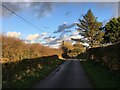
1
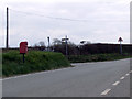
Road junction at Ty'n y Coed
This road junction at Ty'n y Coed is used by several cycle routes, as can be seen on the road sign
Image: © Nigel Williams
Taken: 15 Apr 2006
0.06 miles
2
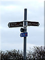
Signpost for cyclists
This signpost on the junction at Ty'n y Coed is for cyclists as several cycle routes pass this point
Image: © Nigel Williams
Taken: 15 Apr 2006
0.06 miles
4
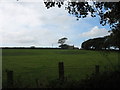
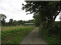
Farmland and cottage north of the hamlet of Tregaian
Image: © Eric Jones
Taken: 8 Sep 2008
0.12 miles