IMAGES TAKEN NEAR TO
LLANGEFNI, LL77 7SL
Introduction
This page details the photographs taken nearby to LL77 7SL by members of the Geograph project.
The Geograph project started in 2005 with the aim of publishing, organising and preserving representative images for every square kilometre of Great Britain, Ireland and the Isle of Man.

There are currently over 7.5m images from over14,400 individuals and you can help contribute to the project by visiting https://www.geograph.org.uk
Image Map (Loading...)


Getting Data...Please wait
Leaflet Map data © OpenStreetMap
Images are licensed for reuse under creativecommons.org/licenses/by-sa/2.0
Notes
- Clicking on the map will re-center to the selected point.
- The higher the marker number, the further away the image location is from the centre of the postcode.
Image Listing (7 Images Found)
Images are licensed for reuse under creativecommons.org/licenses/by-sa/2.0
Image
Details
Distance
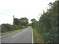
1

The path to Llanffinan with Ty Hen in the background
Image: © Eric Jones
Taken: 1 Aug 2007
0.01 miles
2
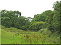
The valley of Afon Ceint
The Ceint is a tributary of Afon Cefni.
Image: © Eric Jones
Taken: 1 Aug 2007
0.16 miles
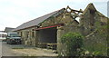
3
Another view of the farm buildings at Plas Penmynydd
Image: © Eric Jones
Taken: 1 Aug 2007
0.23 miles
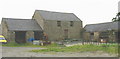
4
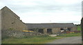
Traditional farm buildings at Plas Penmynydd
Image: © Eric Jones
Taken: 1 Aug 2007
0.23 miles
5
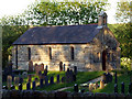
Llanffinan Church
The small church of Llanffinan near to Ceint
Image: © Nigel Williams
Taken: 2 Jun 2006
0.23 miles