IMAGES TAKEN NEAR TO
Penmynydd Road, LLANGEFNI, LL77 7SG
Introduction
This page details the photographs taken nearby to Penmynydd Road, LL77 7SG by members of the Geograph project.
The Geograph project started in 2005 with the aim of publishing, organising and preserving representative images for every square kilometre of Great Britain, Ireland and the Isle of Man.

There are currently over 7.5m images from over14,400 individuals and you can help contribute to the project by visiting https://www.geograph.org.uk
Image Map (Loading...)


Getting Data...Please wait
Leaflet Map data © OpenStreetMap
Images are licensed for reuse under creativecommons.org/licenses/by-sa/2.0
Notes
- Clicking on the map will re-center to the selected point.
- The higher the marker number, the further away the image location is from the centre of the postcode.
Image Listing (12 Images Found)
Images are licensed for reuse under creativecommons.org/licenses/by-sa/2.0
Image
Details
Distance
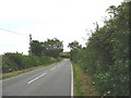
3

Eastward on B5420 at site of Ceint station
Nothing to be seen of Ceint station, but it had been on the ex-LNW Holland Arms (right) - Red Wharf Bay (left) branch, closed to passengers 22/9/30, to goods 3/4/50.
Image: © Ben Brooksbank
Taken: 24 Jun 1986
0.10 miles
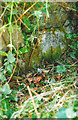
4
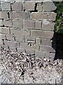
Benchmark on old railway bridge, Ceint
This benchmark is located on the NW parapet of an old railway bridge in Ceint & it is shown in the current Ordnance Survey database at a height of 53.24918m above the Newlyn datum.
Image: © Meirion
Taken: 25 Apr 2011
0.11 miles
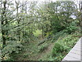
5
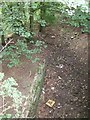
Ceint station platform and trackbed
Viewed from road bridge above the dismantled track this shows the broad outline of the platform of the station which closed in 1950. More detail on this and the Anglesey Central Railway can be found on the following website http://downloads.bbc.co.uk/wales/archive/bbc-north-west-wales-history-red-wharf-bay-railway.pdf
See also Image] Image]
Image: © Richard Hoare
Taken: 4 Sep 2009
0.11 miles
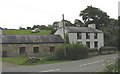
6
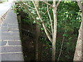
Road bridge crossing the dismantled Anglesey Central Railway line at Ceint (2)
After taking a shot of this bridge last month I was intrigued by the history and was able to secure today this slightly better photo of the outline of the original platform. The track which was lifted many years ago formed the branch line from Holland Arms (Pentre Berw) to Red Wharf Bay. It ceased operation in 1950.
The same bridge features in a website photograph from BBC TV about the railway in question.Indeed the station and platform in its original form can be seen at http://downloads.bbc.co.uk/wales/archive/bbc-north-west-wales-history-red-wharf-bay-railway.pdf See also Image Image
Image: © Richard Hoare
Taken: 4 Sep 2009
0.11 miles
7
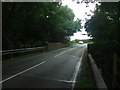
Road bridge crossing dismantled railway at Ceint
The road bridge on the B5420 crossing the dismantled Anglesey Central Railway line. The track which was lifted many years ago formed the branch line from Holland Arms (Pentre Berw) to Red Wharf Bay. It ceased operation in 1950.
The same bridge features in a website photograph from BBC TV about the railway in question. http://downloads.bbc.co.uk/wales/archive/bbc-north-west-wales-history-red-wharf-bay-railway.pdf See also Image] Image]
Image: © Richard Hoare
Taken: 15 Aug 2009
0.12 miles
8
Old Milestone by the B5420, Ceint Bridge, east of Llangefni
By the B5420, in parish of Llanddyfnan (Anglesey District), Ceint Bridge, set into wall.
Inscription defaced.
Surveyed
Milestone Society National ID: ANG_OHH19.
Image: © Milestone Society
Taken: Unknown
0.14 miles
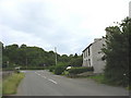
9
The site of Ceint station
Ceint station platform and shelter were to the left of the picture which is taken from the bridge over the old Red Wharf branch of the London and North Western Railway. That line opened in 1909 and closed just 21 years later.
Image: © Philip Lloyd
Taken: 9 Oct 2023
0.15 miles