IMAGES TAKEN NEAR TO
LLANGEFNI, LL77 7SA
Introduction
This page details the photographs taken nearby to LL77 7SA by members of the Geograph project.
The Geograph project started in 2005 with the aim of publishing, organising and preserving representative images for every square kilometre of Great Britain, Ireland and the Isle of Man.

There are currently over 7.5m images from over14,400 individuals and you can help contribute to the project by visiting https://www.geograph.org.uk
Image Map (Loading...)


Getting Data...Please wait
Leaflet Map data © OpenStreetMap
Images are licensed for reuse under creativecommons.org/licenses/by-sa/2.0
Notes
- Clicking on the map will re-center to the selected point.
- The higher the marker number, the further away the image location is from the centre of the postcode.
Image Listing (3 Images Found)
Images are licensed for reuse under creativecommons.org/licenses/by-sa/2.0
Image
Details
Distance
1
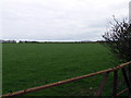
Field near to Angora Farm
Looking East from the country lane out over the grazing land
Image: © Nigel Williams
Taken: 15 Apr 2006
0.16 miles
3
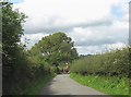
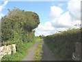
Narrow country lane linking the B 5109 and the B 5110
This country road looks idyllic, but because it forms a section of a cross-country run of unclassified lanes linking 4 busy B-roads, it acquires at peak periods the function of rat-run ring road for motorists wishing to avoid the town of Llangefni.
Image: © Eric Jones
Taken: 13 Sep 2008
0.22 miles