IMAGES TAKEN NEAR TO
Tai Newydd, LLANGEFNI, LL77 7GL
Introduction
This page details the photographs taken nearby to Tai Newydd, LL77 7GL by members of the Geograph project.
The Geograph project started in 2005 with the aim of publishing, organising and preserving representative images for every square kilometre of Great Britain, Ireland and the Isle of Man.

There are currently over 7.5m images from over14,400 individuals and you can help contribute to the project by visiting https://www.geograph.org.uk
Image Map
Images are licensed for reuse under creativecommons.org/licenses/by-sa/2.0
Notes
- Clicking on the map will re-center to the selected point.
- The higher the marker number, the further away the image location is from the centre of the postcode.
Image Listing (6 Images Found)
Images are licensed for reuse under creativecommons.org/licenses/by-sa/2.0
Image
Details
Distance
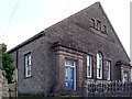
3
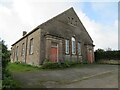
Old chapel at Talwrn
Shown on late 19thC maps as 'Methodist Chapel', the building now appears to be unused, but still in relatively good condition.
Image: © Gordon Hatton
Taken: 25 Sep 2023
0.19 miles
5
Chapel at Talwrn
A Chapel on a minor country road at Talwrn
Image: © Nigel Williams
Taken: 2 Jun 2006
0.25 miles
6
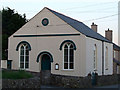
Siloam Chapel in Talwrn
Siloam Chapel in Talwrn was built in 1841, and rebuilt in 1880
Image: © Nigel Williams
Taken: 2 Jun 2006
0.25 miles