IMAGES TAKEN NEAR TO
Stad Penrhiw, LLANGEFNI, LL77 7GD
Introduction
This page details the photographs taken nearby to Stad Penrhiw, LL77 7GD by members of the Geograph project.
The Geograph project started in 2005 with the aim of publishing, organising and preserving representative images for every square kilometre of Great Britain, Ireland and the Isle of Man.

There are currently over 7.5m images from over14,400 individuals and you can help contribute to the project by visiting https://www.geograph.org.uk
Image Map (Loading...)


Getting Data...Please wait
Leaflet Map data © OpenStreetMap
Images are licensed for reuse under creativecommons.org/licenses/by-sa/2.0
Notes
- Clicking on the map will re-center to the selected point.
- The higher the marker number, the further away the image location is from the centre of the postcode.
Image Listing (30 Images Found)
Images are licensed for reuse under creativecommons.org/licenses/by-sa/2.0
Image
Details
Distance
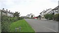
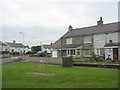
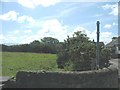
2
Old and new houses next to the playing field
Image: © Eric Jones
Taken: 16 Jul 2008
0.10 miles
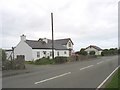
4
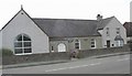
Capel Pisgah (Baptist) and chapel house
This chapel was built in 1875.
Image: © Eric Jones
Taken: 16 Jul 2008
0.11 miles
6
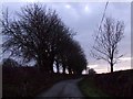
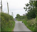
Dusk in the country lane
This is the lane behind the Tafarn y Rhos public house looking south
Image: © Nigel Williams
Taken: 15 Feb 2006
0.12 miles
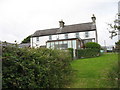
8
Farmland and lane used as a public footpath at Rhostrehwfa
Image: © Eric Jones
Taken: 4 Jul 2008
0.13 miles
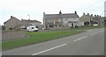
9
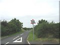
Minor road leading northwards from the B 4422
Image: © Eric Jones
Taken: 28 Jun 2008
0.13 miles