IMAGES TAKEN NEAR TO
Rhostrehwfa, LLANGEFNI, LL77 7AX
Introduction
This page details the photographs taken nearby to LL77 7AX by members of the Geograph project.
The Geograph project started in 2005 with the aim of publishing, organising and preserving representative images for every square kilometre of Great Britain, Ireland and the Isle of Man.

There are currently over 7.5m images from over14,400 individuals and you can help contribute to the project by visiting https://www.geograph.org.uk
Image Map
Images are licensed for reuse under creativecommons.org/licenses/by-sa/2.0
Notes
- Clicking on the map will re-center to the selected point.
- The higher the marker number, the further away the image location is from the centre of the postcode.
Image Listing (8 Images Found)
Images are licensed for reuse under creativecommons.org/licenses/by-sa/2.0
Image
Details
Distance
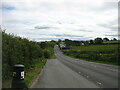
2
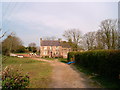
Glanrafon, Cae Garw.
Looking towards Glanrafon Farmhouse from the Road.
Image: © Stephen Elwyn RODDICK
Taken: 9 Apr 2002
0.09 miles
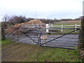
3
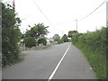
View back towards the junction with the B5109
Image: © Eric Jones
Taken: 16 Jul 2008
0.20 miles
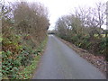
4
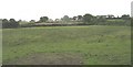
View across fields in the direction of the ribbon development along the B4422 Rhostrehwfa road
Image: © Eric Jones
Taken: 16 Jul 2008
0.20 miles
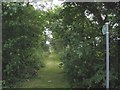
5
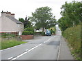
The T-junction at Ty'n Pwll on the B 5109
The hollow beyond descends to Pont Rhyd Ysbardun (=spur ford bridge).
Image: © Eric Jones
Taken: 16 Jul 2008
0.20 miles