IMAGES TAKEN NEAR TO
Red Wharf Bay, PENTRAETH, LL75 8EX
Introduction
This page details the photographs taken nearby to LL75 8EX by members of the Geograph project.
The Geograph project started in 2005 with the aim of publishing, organising and preserving representative images for every square kilometre of Great Britain, Ireland and the Isle of Man.

There are currently over 7.5m images from over14,400 individuals and you can help contribute to the project by visiting https://www.geograph.org.uk
Image Map
Images are licensed for reuse under creativecommons.org/licenses/by-sa/2.0
Notes
- Clicking on the map will re-center to the selected point.
- The higher the marker number, the further away the image location is from the centre of the postcode.
Image Listing (39 Images Found)
Images are licensed for reuse under creativecommons.org/licenses/by-sa/2.0
Image
Details
Distance
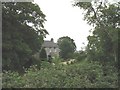
2
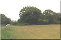
Traditional stone barn at Croesfryn Farm
Image: © Eric Jones
Taken: 26 Jul 2008
0.12 miles
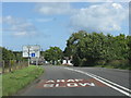
5
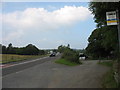
The south-bound bus stop at Croesfryn on the A5025
Image: © Eric Jones
Taken: 26 Jul 2008
0.15 miles
7
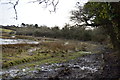
Vegetation choked cutting at the northern end of the embankment near Llanbedrgoch
Somewhere within the cutting are two bridges, the old railway bridge and its modern replacement, carrying the A 5025.
Image: © Eric Jones
Taken: 29 Jun 2008
0.16 miles
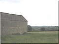
8
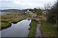
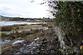
Footbridge, Anglesey Coast Path, Red Wharf Bay
Image: © N Chadwick
Taken: 20 Feb 2015
0.16 miles
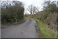
10
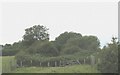
Railway bridge carrying the old A 5025 west of Croesfryn
This bridge is not accessible and is partly obscured by trees and bushes. Across the new section of the A road there is a path leading south parallel with the railway embankment. This bridge is not visible from the south.
Image: © Eric Jones
Taken: 26 Jul 2008
0.18 miles