IMAGES TAKEN NEAR TO
Bwlch, TYN-Y-GONGL, LL74 8RH
Introduction
This page details the photographs taken nearby to LL74 8RH by members of the Geograph project.
The Geograph project started in 2005 with the aim of publishing, organising and preserving representative images for every square kilometre of Great Britain, Ireland and the Isle of Man.

There are currently over 7.5m images from over14,400 individuals and you can help contribute to the project by visiting https://www.geograph.org.uk
Image Map
Images are licensed for reuse under creativecommons.org/licenses/by-sa/2.0
Notes
- Clicking on the map will re-center to the selected point.
- The higher the marker number, the further away the image location is from the centre of the postcode.
Image Listing (10 Images Found)
Images are licensed for reuse under creativecommons.org/licenses/by-sa/2.0
Image
Details
Distance
1

Afon Marchogion, Isle of Anglesey
This small river drains the area around Cors Goch (SH4981) and enters the sea at Benllech (SH522827). Taken from SH508822.
Image: © Keith Williamson
Taken: 21 Jul 2005
0.02 miles
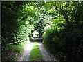
2
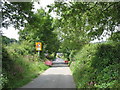
The temporarily closed road to Bwlch
Open to residents and footsloggers only. Work is being undertaken in the area by Welsh Water.
Image: © Eric Jones
Taken: 26 Jul 2008
0.12 miles
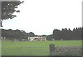
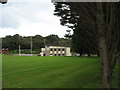
3
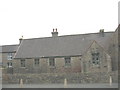
Social Club at the Benllech Rugby Grounds, Tynygongl
Image: © Eric Jones
Taken: 8 Sep 2008
0.13 miles
8
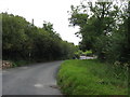
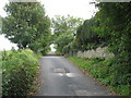
The back road to Benllech
This road is known as the Bwlch (=pass/gap) Road.
Image: © Eric Jones
Taken: 8 Sep 2008
0.16 miles
9
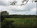
A well wooded area above the incised Afon Marchogion valley
Image: © Eric Jones
Taken: 8 Sep 2008
0.18 miles