IMAGES TAKEN NEAR TO
Einion Lane, LLANNERCH-Y-MEDD, LL71 8EF
Introduction
This page details the photographs taken nearby to Einion Lane, LL71 8EF by members of the Geograph project.
The Geograph project started in 2005 with the aim of publishing, organising and preserving representative images for every square kilometre of Great Britain, Ireland and the Isle of Man.

There are currently over 7.5m images from over14,400 individuals and you can help contribute to the project by visiting https://www.geograph.org.uk
Image Map
Images are licensed for reuse under creativecommons.org/licenses/by-sa/2.0
Notes
- Clicking on the map will re-center to the selected point.
- The higher the marker number, the further away the image location is from the centre of the postcode.
Image Listing (54 Images Found)
Images are licensed for reuse under creativecommons.org/licenses/by-sa/2.0
Image
Details
Distance
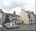
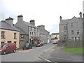
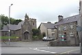
4
View along the High Street in the direction of the Square
Image: © Eric Jones
Taken: 12 Jul 2008
0.03 miles
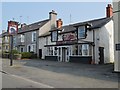
5
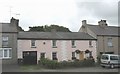
Early 18thC houses in the High Street
These houses bear the date of 1724.
Image: © Eric Jones
Taken: 12 Jul 2008
0.04 miles
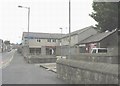
6
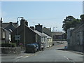
Approaching The Roundabout, Llanerchymedd
Image: © Peter Whatley
Taken: 5 Aug 2009
0.04 miles
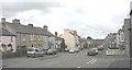
7
View east along Bridge Street towards the Square
Image: © Eric Jones
Taken: 12 Jul 2008
0.04 miles
8
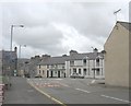
Sgwar Llan. The Central Square at Llannerch-y-Medd
This for centuries has been the place to hang-out.
Image: © Eric Jones
Taken: 12 Jul 2008
0.04 miles
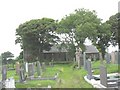
10
The Church of St Mary, the lych gate and the old rectory viewed across the town square
Image: © Eric Jones
Taken: 12 Jul 2008
0.05 miles