IMAGES TAKEN NEAR TO
The Square, LLANNERCH-Y-MEDD, LL71 8DA
Introduction
This page details the photographs taken nearby to The Square, LL71 8DA by members of the Geograph project.
The Geograph project started in 2005 with the aim of publishing, organising and preserving representative images for every square kilometre of Great Britain, Ireland and the Isle of Man.

There are currently over 7.5m images from over14,400 individuals and you can help contribute to the project by visiting https://www.geograph.org.uk
Image Map
Images are licensed for reuse under creativecommons.org/licenses/by-sa/2.0
Notes
- Clicking on the map will re-center to the selected point.
- The higher the marker number, the further away the image location is from the centre of the postcode.
Image Listing (52 Images Found)
Images are licensed for reuse under creativecommons.org/licenses/by-sa/2.0
Image
Details
Distance
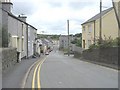
1
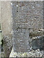
Benchmark on St Mary's lychgate, Llanerchymedd
Ordnance Survey benchmark on the west side of St Mary's lychgate. The mark is recorded on old maps levelled at 222.8 feet above Liverpool Datum. For a wider view see Image
Benchmark Database: https://www.bench-marks.org.uk/bm35364
Image: © John S Turner
Taken: 30 Aug 2015
0.02 miles
2
St Mary's lychgate from Market Square, Llanerchymedd
There is an Ordnance Survey benchmark to the right of the gate on St Mary's lychgate Image
Image: © John S Turner
Taken: 30 Aug 2015
0.02 miles
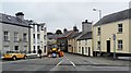
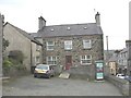
3
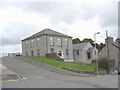
Meddygfa Glan Menai GP Surgery, Bridge Street
www.coedyglynsurgery.co.uk/contact_cm.htm
Image: © Eric Jones
Taken: 12 Jul 2008
0.02 miles
4
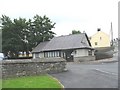
Capel Ifan Congregational Chapel, Bridge Street
Capel Ifan was built in 1861 on the site of an earlier chapel. Its construction cost all of £500. The vestry was added in 1926.
Image: © Eric Jones
Taken: 12 Jul 2008
0.02 miles
6
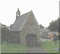
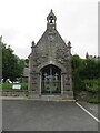
The lych gate of St Mary's Church
This lych gate is bigger than many Anglesey churches. It was built in 1755. It overlooks the town's square.
Image: © Eric Jones
Taken: 12 Jul 2008
0.04 miles
7
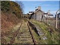
Llanerchymedd station, Anglesey.
Passenger trains on the single line branch to Amlwch, on the north coast of the island, were withdrawn in 1964. Llanerchymedd station was located eleven miles from Gaerwen on the main line and six miles south of the terminus at Amlwch.
Image: © Ralph Rawlinson
Taken: 20 Mar 2005
0.04 miles
10
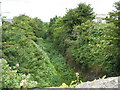
The line of the Amlwch branch line immediately north of Llannerch-y-Medd station
The branch line from Llangefni to Llannerch-y-medd was completed in 1866 and the extension on to Amlwch took place the following year. Passenger services were withdrawn in 1964 but the line was kept open to serve the Associated Octel bromine plant at Amlwch. In 1993, however all services were withdrawn and the line has gone the way of the Holland Arms to Benllech line which was closed in 1950.
www.penmorfa.com/Archive/
Image: © Eric Jones
Taken: 12 Jul 2008
0.04 miles