IMAGES TAKEN NEAR TO
Mynydd Bodafon, LLANNERCH-Y-MEDD, LL71 8BN
Introduction
This page details the photographs taken nearby to LL71 8BN by members of the Geograph project.
The Geograph project started in 2005 with the aim of publishing, organising and preserving representative images for every square kilometre of Great Britain, Ireland and the Isle of Man.

There are currently over 7.5m images from over14,400 individuals and you can help contribute to the project by visiting https://www.geograph.org.uk
Image Map (Loading...)


Getting Data...Please wait
Leaflet Map data © OpenStreetMap
Images are licensed for reuse under creativecommons.org/licenses/by-sa/2.0
Notes
- Clicking on the map will re-center to the selected point.
- The higher the marker number, the further away the image location is from the centre of the postcode.
Image Listing (18 Images Found)
Images are licensed for reuse under creativecommons.org/licenses/by-sa/2.0
Image
Details
Distance
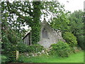
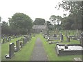
1
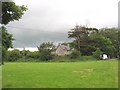
Field separating St Mihangel's Church from the road
St Mihangel's round churchyard is separated from the road by a field. The large house is the former vicarage.
Image: © Eric Jones
Taken: 13 Aug 2008
0.07 miles
2
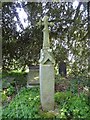
An old cross in the churchyard of St. Michael's Church, Penrhoslligwy
Originally a 14th or 15th century gable end cross it is now mounted on a stone shaft in the churchyard.
Image: © Meirion
Taken: 21 Apr 2011
0.08 miles
3
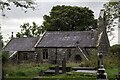
St Michaels Church, Penrhosllugwy
** The earliest dateable features, the chancel arch and E window, date to c1400, but the fabric may be earlier. The church was restored by Henry Kennedy in 1865, when the N porch and vestry were added and new windows installed.
A Grade II Listed Building.
** Courtesy British Listed Buildings.
Image: © Arthur C Harris
Taken: 11 Oct 2021
0.08 miles
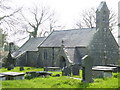
4
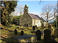
The Church of St Michael Penrhosllugwy
Viewed from the south-west.
Image: © Peter Wood
Taken: 4 Dec 2017
0.09 miles
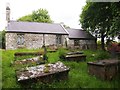
5
St. Michael's Church, Penrhoslligwy
An interesting old church with much history for the visitor to enjoy.
Image: © Meirion
Taken: 21 Apr 2011
0.09 miles
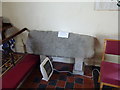
6
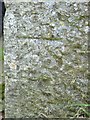
Benchmark on St. Michael's Church, Penrhoslligwy
This benchmark is located on the N face of the porch at St. Michael's Church in Penrhoslligwy. The mark is not in the current Ordnance Survey database but is shown on an 1900 map of the area at a height of 200.1ft above the Liverpool datum.
Image: © Meirion
Taken: 21 Apr 2011
0.09 miles
8
The eastern gable of Eglwys St Mihangel/Michael Church, Penrhosllugwy
http://www.royalcharterchurch.org.uk/
Image: © Eric Jones
Taken: 13 Aug 2008
0.09 miles
9
Mynwent ac Eglwys St Mihangel Churchyard and Church, Penrhosllugwy
Image: © Eric Jones
Taken: 13 Aug 2008
0.09 miles
10
The Maccudecceti stone - St. Michael's Church, Penrhoslligwy
Located on the S side of the chancel the Maccudecceti stone dated to around 525AD, bears a latin inscription translated as ' Here lies Maccudecceti'.
Image: © Meirion
Taken: 21 Apr 2011
0.10 miles