IMAGES TAKEN NEAR TO
Mynydd Bodafon, LLANNERCH-Y-MEDD, LL71 8BH
Introduction
This page details the photographs taken nearby to LL71 8BH by members of the Geograph project.
The Geograph project started in 2005 with the aim of publishing, organising and preserving representative images for every square kilometre of Great Britain, Ireland and the Isle of Man.

There are currently over 7.5m images from over14,400 individuals and you can help contribute to the project by visiting https://www.geograph.org.uk
Image Map (Loading...)


Getting Data...Please wait
Leaflet Map data © OpenStreetMap
Images are licensed for reuse under creativecommons.org/licenses/by-sa/2.0
Notes
- Clicking on the map will re-center to the selected point.
- The higher the marker number, the further away the image location is from the centre of the postcode.
Image Listing (5 Images Found)
Images are licensed for reuse under creativecommons.org/licenses/by-sa/2.0
Image
Details
Distance
3
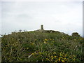
Yr Arwydd, Anglesey
The trig point on the summit of Yr Arwydd, Mynydd Bodafon, Anglesey. At 178m, the highest point on the main island of Anglesey. SH472854.
Image: © Keith Williamson
Taken: 1 May 2005
0.25 miles
4
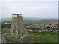
Summit view, Yr Arwydd, Anglesey
A closer view of the trig point on this, the highest point on the main island of Anglesey. Dulas Bay and Traeth Dulas can be seen in the distance. SH472854.
Image: © Keith Williamson
Taken: 1 May 2005
0.25 miles
5
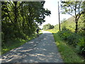
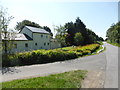
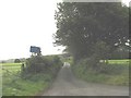
Road near Yr Arwydd
The junction on the left is the entrance to Plas Bodafon.
Image: © David Medcalf
Taken: 23 Jul 2014
0.25 miles