IMAGES TAKEN NEAR TO
Mynydd Bodafon, LLANNERCH-Y-MEDD, LL71 8BG
Introduction
This page details the photographs taken nearby to LL71 8BG by members of the Geograph project.
The Geograph project started in 2005 with the aim of publishing, organising and preserving representative images for every square kilometre of Great Britain, Ireland and the Isle of Man.

There are currently over 7.5m images from over14,400 individuals and you can help contribute to the project by visiting https://www.geograph.org.uk
Image Map (Loading...)


Getting Data...Please wait
Leaflet Map data © OpenStreetMap
Images are licensed for reuse under creativecommons.org/licenses/by-sa/2.0
Notes
- Clicking on the map will re-center to the selected point.
- The higher the marker number, the further away the image location is from the centre of the postcode.
Image Listing (26 Images Found)
Images are licensed for reuse under creativecommons.org/licenses/by-sa/2.0
Image
Details
Distance
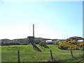
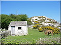
1
View back towards the reservoir tower from Barclodiau
Image: © Eric Jones
Taken: 1 May 2007
0.05 miles

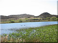
9
View across to Llyn Bodafon and Pen-y-castell
Image: © Eric Jones
Taken: 1 May 2007
0.10 miles
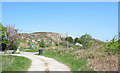
10
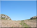
Col and footpath above the Barclodiau track
Image: © Eric Jones
Taken: 1 May 2007
0.11 miles