IMAGES TAKEN NEAR TO
Maenaddwyn, LLANNERCH-Y-MEDD, LL71 8BE
Introduction
This page details the photographs taken nearby to LL71 8BE by members of the Geograph project.
The Geograph project started in 2005 with the aim of publishing, organising and preserving representative images for every square kilometre of Great Britain, Ireland and the Isle of Man.

There are currently over 7.5m images from over14,400 individuals and you can help contribute to the project by visiting https://www.geograph.org.uk
Image Map (Loading...)


Getting Data...Please wait
Leaflet Map data © OpenStreetMap
Images are licensed for reuse under creativecommons.org/licenses/by-sa/2.0
Notes
- Clicking on the map will re-center to the selected point.
- The higher the marker number, the further away the image location is from the centre of the postcode.
Image Listing (3 Images Found)
Images are licensed for reuse under creativecommons.org/licenses/by-sa/2.0
Image
Details
Distance
1
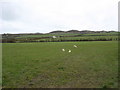
View across pasture land to Wern Cottage and Mynydd Bodafon
Wern is a typical Anglesey whitewashed cottage.
Image: © Eric Jones
Taken: 28 Mar 2009
0.02 miles
2
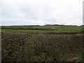
The lower slopes of Mynydd Bodafon from the Maenaddwyn road
The white cottage on the slope is called "Wern" (=meadow)
Image: © Eric Jones
Taken: 28 Mar 2009
0.02 miles
3
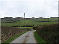
The start of the footpath to Mynydd Bodafon
Image: © Eric Jones
Taken: 28 Mar 2009
0.23 miles