IMAGES TAKEN NEAR TO
Llandyfrydog, LLANNERCH-Y-MEDD, LL71 8AH
Introduction
This page details the photographs taken nearby to LL71 8AH by members of the Geograph project.
The Geograph project started in 2005 with the aim of publishing, organising and preserving representative images for every square kilometre of Great Britain, Ireland and the Isle of Man.

There are currently over 7.5m images from over14,400 individuals and you can help contribute to the project by visiting https://www.geograph.org.uk
Image Map (Loading...)


Getting Data...Please wait
Leaflet Map data © OpenStreetMap
Images are licensed for reuse under creativecommons.org/licenses/by-sa/2.0
Notes
- Clicking on the map will re-center to the selected point.
- The higher the marker number, the further away the image location is from the centre of the postcode.
Image Listing (10 Images Found)
Images are licensed for reuse under creativecommons.org/licenses/by-sa/2.0
Image
Details
Distance
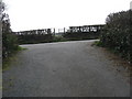
1
Bend in the road below Tan yr Allt cottage
Tan yr Allt means "below the hill".
Image: © Eric Jones
Taken: 28 Mar 2009
0.03 miles
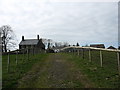
2
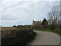
The hill leading up to Bryn Dyfrydog Farm
The white cottage is Efail Newydd (=new smithy).
Image: © Eric Jones
Taken: 28 Mar 2009
0.10 miles
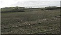
3
Farm road to the now ruined Plas Llandyfrydog
Image: © Eric Jones
Taken: 28 Mar 2009
0.14 miles
4
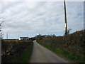
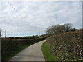
Neatly trimmed hedgerows along the road south of Tan yr Allt
It's a saying in the countryside that "Well trimmed hedgerows are a sign of a good farmer".
Image: © Eric Jones
Taken: 28 Mar 2009
0.15 miles
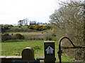
5
A kissing gate on the path leading past Plas Llandyfrydog
Plas Llandyfrydog farmhouse is now a roofless ruin.
Image: © Eric Jones
Taken: 28 Mar 2009
0.15 miles
6
View across a ploughed field towards the ruined Plas Llandyfrydog farmhouse
Image: © Eric Jones
Taken: 28 Mar 2009
0.17 miles
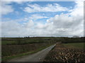
8
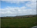
View northeastwards across farmland at Bryn Dyfrydog
Bryn Dyfrydog is a pastoral unit specializing in the rearing of Welsh Black cattle.
Image: © Eric Jones
Taken: 28 Mar 2009
0.20 miles
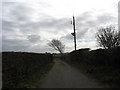
9
Road northwards below Bryn Dyfrydog Farm
Image: © Eric Jones
Taken: 28 Mar 2009
0.24 miles
10
Footpath from Llandyfrydog Church to Bryn Eglwys
This footpath is part of the Anglesey Three Lighthouse Path. This is indicated by the way mark on the gate.
Image: © Eric Jones
Taken: 28 Mar 2009
0.24 miles