IMAGES TAKEN NEAR TO
Llandrygan, LLANNERCH-Y-MEDD, LL71 7AW
Introduction
This page details the photographs taken nearby to LL71 7AW by members of the Geograph project.
The Geograph project started in 2005 with the aim of publishing, organising and preserving representative images for every square kilometre of Great Britain, Ireland and the Isle of Man.

There are currently over 7.5m images from over14,400 individuals and you can help contribute to the project by visiting https://www.geograph.org.uk
Image Map
Images are licensed for reuse under creativecommons.org/licenses/by-sa/2.0
Notes
- Clicking on the map will re-center to the selected point.
- The higher the marker number, the further away the image location is from the centre of the postcode.
Image Listing (11 Images Found)
Images are licensed for reuse under creativecommons.org/licenses/by-sa/2.0
Image
Details
Distance
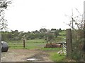
3
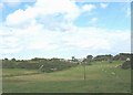
Gwyndy Aggregate Quarry, Llandrygarn
This quarry is owned by the Hogan Group of Bangor.
Image: © Eric Jones
Taken: 25 Sep 2008
0.11 miles
4
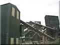
The Gwyndy Aggregate Quarry from the B 5109
Image: © Eric Jones
Taken: 25 Sep 2008
0.12 miles
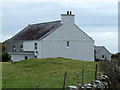
5
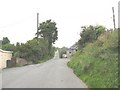
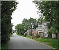
Castell Cottage on the Llandrygarn-Llannerch-y-medd road
Image: © Eric Jones
Taken: 25 Sep 2008
0.13 miles
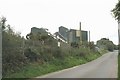
6
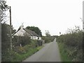
Cottage with a nissen hut garage near Gwyndy Granite Quarry
This cottage is named on OS plans, dating back to the end of the 19thC, as Hen-shop (=old shop).
Image: © Eric Jones
Taken: 25 Sep 2008
0.14 miles
9
Capel Seion and Cae'r-gof Farm from Penyrallt
Capel Seion, a Calvinistic Methodist chapel, was built in 1817. It was still open in 2007.
Image: © Eric Jones
Taken: 25 Sep 2008
0.19 miles
10
Converted Chapel near to Llandrygan
A chapel that has been converted into a dwelling near to Llandrygan
Image: © Nigel Williams
Taken: 15 Apr 2006
0.19 miles