IMAGES TAKEN NEAR TO
Llandrygan, LLANNERCH-Y-MEDD, LL71 7AR
Introduction
This page details the photographs taken nearby to LL71 7AR by members of the Geograph project.
The Geograph project started in 2005 with the aim of publishing, organising and preserving representative images for every square kilometre of Great Britain, Ireland and the Isle of Man.

There are currently over 7.5m images from over14,400 individuals and you can help contribute to the project by visiting https://www.geograph.org.uk
Image Map (Loading...)


Getting Data...Please wait
Leaflet Map data © OpenStreetMap
Images are licensed for reuse under creativecommons.org/licenses/by-sa/2.0
Notes
- Clicking on the map will re-center to the selected point.
- The higher the marker number, the further away the image location is from the centre of the postcode.
Image Listing (2 Images Found)
Images are licensed for reuse under creativecommons.org/licenses/by-sa/2.0
Image
Details
Distance
1
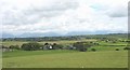
Tre'r-ddol farmhouse from Llechcynfarwy
Tre'r-ddol was the home of the Bold family whose ancestors included Owen Tudur of Penmynydd, the executed grandfather of Henry VII, Hwlcyn Bodychen, a leading figure in the Owain Glyndwr rebellion and Rhys Bodychen, a hero of the Battle of Bosworth.
Image: © Eric Jones
Taken: 12 Jul 2008
0.06 miles
2

Tre'r dd?l, Llechcynfarwy
A 17C farmhouse.
Image: © Humphrey Bolton
Taken: Unknown
0.06 miles