IMAGES TAKEN NEAR TO
LLANNERCH-Y-MEDD, LL71 7AF
Introduction
This page details the photographs taken nearby to LL71 7AF by members of the Geograph project.
The Geograph project started in 2005 with the aim of publishing, organising and preserving representative images for every square kilometre of Great Britain, Ireland and the Isle of Man.

There are currently over 7.5m images from over14,400 individuals and you can help contribute to the project by visiting https://www.geograph.org.uk
Image Map (Loading...)


Getting Data...Please wait
Leaflet Map data © OpenStreetMap
Images are licensed for reuse under creativecommons.org/licenses/by-sa/2.0
Notes
- Clicking on the map will re-center to the selected point.
- The higher the marker number, the further away the image location is from the centre of the postcode.
Image Listing (8 Images Found)
Images are licensed for reuse under creativecommons.org/licenses/by-sa/2.0
Image
Details
Distance
2
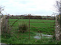
Iron gate leading into a field
An iron gate leading into a field to the south of llanerchymedd
Image: © Nigel Williams
Taken: 15 Apr 2006
0.11 miles
3
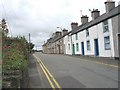
Terraced housing in Holyhead Road (B 5112)
Image: © Eric Jones
Taken: 12 Jul 2008
0.17 miles
4

Dairy herd and telephone mast at Bryn Medd Farm
Image: © Eric Jones
Taken: 25 Sep 2008
0.17 miles
5

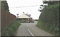
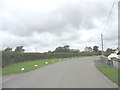
The B 5112 near Joint Houses Rhodogeidio
Here, the road climbs uphill from the direction of Llannerch-y-medd.
Image: © Eric Jones
Taken: 25 Sep 2008
0.23 miles
6
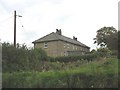
Joint Houses Rhodogeidio
This is a block of four local authority-built houses.
Image: © Eric Jones
Taken: 25 Sep 2008
0.23 miles
7

Bryn Medd Farm, Llannerch-y-medd
Bryn Medd means "mead hill", whilst Llannerch-y-medd means "glade of the mead".
Image: © Eric Jones
Taken: 25 Sep 2008
0.23 miles
8
A sweeping curve south of Bryn-garth farm
Image: © Eric Jones
Taken: 12 Jul 2008
0.24 miles