IMAGES TAKEN NEAR TO
Chwaen Terrace, Holyhead Road, LLANNERCH-Y-MEDD, LL71 7AD
Introduction
This page details the photographs taken nearby to Chwaen Terrace, Holyhead Road, LL71 7AD by members of the Geograph project.
The Geograph project started in 2005 with the aim of publishing, organising and preserving representative images for every square kilometre of Great Britain, Ireland and the Isle of Man.

There are currently over 7.5m images from over14,400 individuals and you can help contribute to the project by visiting https://www.geograph.org.uk
Image Map
Images are licensed for reuse under creativecommons.org/licenses/by-sa/2.0
Notes
- Clicking on the map will re-center to the selected point.
- The higher the marker number, the further away the image location is from the centre of the postcode.
Image Listing (37 Images Found)
Images are licensed for reuse under creativecommons.org/licenses/by-sa/2.0
Image
Details
Distance
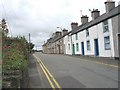
1
The junction of Bridge Street and Goedwig Street
Image: © Eric Jones
Taken: 12 Jul 2008
0.03 miles
2
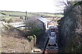
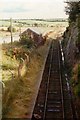
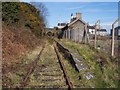
Llanerchymedd Station
The former station on the disused Amlwch branch line.
Image: © Kevin Williams
Taken: 17 Apr 2010
0.05 miles
3
Benchmark on railway bridge, Llanerchymedd
Ordnance Survey benchmark on Bridge Street railway bridge, Llanerchymedd. For a wider view see: Image Levelled at 71.469m above Newlyn Datum, verified 1975.
Benchmark database: https://www.bench-marks.org.uk/bm35363
Image: © John S Turner
Taken: 30 Aug 2015
0.05 miles
4
Bridge Street railway bridge, Llanerchymedd
Bridge Street railway bridge has an Ordnance Survey benchmark on the stone wall, indicated by the white-painted arrow Image
Image: © John S Turner
Taken: 30 Aug 2015
0.05 miles
5
Llanerchymedd railway station
Taken while on holiday in the early 1990s. At the time, the railway had not long been out of use. This is the old branch line to Almlwych, opened as the Anglesey Central Railway between 1864 and 1867. Like most independent railways, they had no money, and so operation of the line was taken over by the London & North Western Railway from 1876. The line was closed to passengers by Beeching in 1964, but remained open for freight to the Associated Octel plant at Amlwych until 1993. My best guess as to the date is 1994; I know the trains were no longer running at the time I took this.
Image: © John Winder
Taken: Unknown
0.06 miles
6
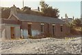
Llanerchymedd station building
Here's another view of the derelict station building at Llanerchymedd, taken in 1994 from what was once the goods yard. While trying to locate where this photograph was taken (well, it was a long time ago!), I discovered that the station building has been refurbished and reopened as an information and heritage centre for the village, which is nice. There's an ongoing campaign to reopen the railway, too.
Image: © John Winder
Taken: Unknown
0.06 miles
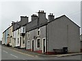
8
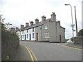
Terraced housing in Holyhead Road (B 5112)
Image: © Eric Jones
Taken: 12 Jul 2008
0.07 miles
9
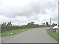
A sweeping curve south of Bryn-garth farm
Image: © Eric Jones
Taken: 12 Jul 2008
0.07 miles
10
Llanerchymedd station, Anglesey.
Passenger trains on the single line branch to Amlwch, on the north coast of the island, were withdrawn in 1964. Llanerchymedd station was located eleven miles from Gaerwen on the main line and six miles south of the terminus at Amlwch.
Image: © Ralph Rawlinson
Taken: 20 Mar 2005
0.07 miles