IMAGES TAKEN NEAR TO
DULAS, LL70 9HX
Introduction
This page details the photographs taken nearby to LL70 9HX by members of the Geograph project.
The Geograph project started in 2005 with the aim of publishing, organising and preserving representative images for every square kilometre of Great Britain, Ireland and the Isle of Man.

There are currently over 7.5m images from over14,400 individuals and you can help contribute to the project by visiting https://www.geograph.org.uk
Image Map
Images are licensed for reuse under creativecommons.org/licenses/by-sa/2.0
Notes
- Clicking on the map will re-center to the selected point.
- The higher the marker number, the further away the image location is from the centre of the postcode.
Image Listing (19 Images Found)
Images are licensed for reuse under creativecommons.org/licenses/by-sa/2.0
Image
Details
Distance
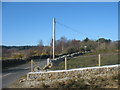
1
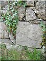
Benchmark on wall opposite Bronllwyd, Rh?s Lligwy
This benchmark is located on the S side of the road on the wall opposite Bronllwyd in Rhôs Lligwy & it is shown in the current Ordnance Survey database at a height of 43.9004m above the Newlyn datum.
Image: © Meirion
Taken: 21 Apr 2011
0.01 miles
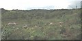
4
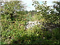
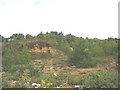
View over the dry stone wall into scrub
The scrub land looks lovely though.
Image: © Jeremy Bolwell
Taken: 2 Sep 2011
0.11 miles
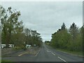
5
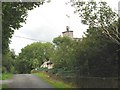
Minor road to Mynydd Bodafon
This road leads from the A5025.
Image: © Eric Jones
Taken: 2 Apr 2009
0.15 miles
6

Road bridge on the lane
A bit tight for two vehicles.
Image: © Jeremy Bolwell
Taken: 2 Sep 2011
0.16 miles
9
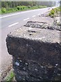
Rivet benchmark on old milk churn stand, Rh?s Lligwy
This rivet benchmark is located on the corner of an old milk churn stand on the SW side of the A5025 near Rhôs Lligwy & it is shown in the current Ordnance Survey database at a height of 35.9455m above the Newlyn datum.
Image: © Meirion
Taken: 21 Apr 2011
0.17 miles
10
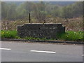
Remains of a old milk churn stand on the A5025, Rh?s Lligwy
Image: © Meirion
Taken: 21 Apr 2011
0.17 miles