IMAGES TAKEN NEAR TO
PENYSARN, LL69 9YY
Introduction
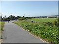
This page details the photographs taken nearby to LL69 9YY by members of the Geograph project.
The Geograph project started in 2005 with the aim of publishing, organising and preserving representative images for every square kilometre of Great Britain, Ireland and the Isle of Man.

There are currently over 7.5m images from over14,400 individuals and you can help contribute to the project by visiting https://www.geograph.org.uk
Image Map
Images are licensed for reuse under creativecommons.org/licenses/by-sa/2.0
Notes
- Clicking on the map will re-center to the selected point.
- The higher the marker number, the further away the image location is from the centre of the postcode.
Image Listing (19 Images Found)
Images are licensed for reuse under creativecommons.org/licenses/by-sa/2.0
Image
Details
Distance
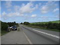
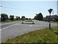
8
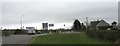
Road junction at Gadfa
The minor road on the right - Lon Gadfa - links the major road, the A5025, with the B5111 just north of Llannerch-y-medd.
Image: © Eric Jones
Taken: 11 Mar 2009
0.18 miles
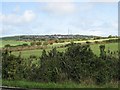
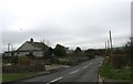
9
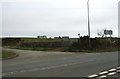
Farm access road joining the A5025 at Gadfa
This road leads to Castell Maelgwyn Farm, seen in the background.
Image: © Eric Jones
Taken: 11 Mar 2009
0.18 miles