IMAGES TAKEN NEAR TO
Penrhyd, AMLWCH, LL68 9TP
Introduction
This page details the photographs taken nearby to LL68 9TP by members of the Geograph project.
The Geograph project started in 2005 with the aim of publishing, organising and preserving representative images for every square kilometre of Great Britain, Ireland and the Isle of Man.

There are currently over 7.5m images from over14,400 individuals and you can help contribute to the project by visiting https://www.geograph.org.uk
Image Map
Images are licensed for reuse under creativecommons.org/licenses/by-sa/2.0
Notes
- Clicking on the map will re-center to the selected point.
- The higher the marker number, the further away the image location is from the centre of the postcode.
Image Listing (19 Images Found)
Images are licensed for reuse under creativecommons.org/licenses/by-sa/2.0
Image
Details
Distance
1
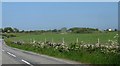
Gorse covered rock outcrops at Bodgadfa Farm
Image: © Eric Jones
Taken: 29 May 2009
0.07 miles
2
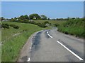
Winding and narrowing section of the road
Image: © Eric Jones
Taken: 29 May 2009
0.07 miles
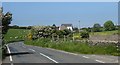
3
The Rhosgoch road south of the former Capel Saron
The farm on the left is Ty'n-y-coed Farm. Its name means "homestead in the woods"
Image: © Eric Jones
Taken: 11 May 2009
0.08 miles
4
Bend in the road south of the former Capel Saron chapel
Image: © Eric Jones
Taken: 29 May 2009
0.09 miles
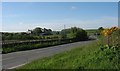
5
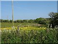
Wetland and powerlines west of the Lastra road
Image: © Eric Jones
Taken: 29 May 2009
0.10 miles
6
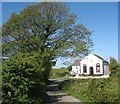
The former Capel Saron, Bodgadfa
This former Congregational/Independent (Annibynwyr) chapel dates from 1844. In 1997, the chapel was closed and the building converted to become part of the chapel house.
Image: © Eric Jones
Taken: 11 May 2009
0.14 miles
7
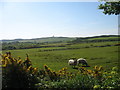
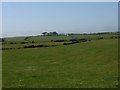
View south across pasture land in the direction of Parys Mountain
The headframe of the modern Anglesey Mining mine is visible on the skyline. This area is more suitable to pastoral rather than arable farming.
Image: © Eric Jones
Taken: 11 May 2009
0.14 miles
8
Track with public access west of the former Capel Saron
Image: © Eric Jones
Taken: 11 May 2009
0.15 miles
9
View across undulating pasture land towards Bodelffra
Image: © Eric Jones
Taken: 29 May 2009
0.20 miles
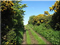
10
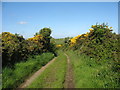
Track between Capel Saron and the Hafod Onnen Crossroads
This provides a short cut across country.
Image: © Eric Jones
Taken: 11 May 2009
0.20 miles