IMAGES TAKEN NEAR TO
Rhosybol, AMLWCH, LL68 9PW
Introduction
This page details the photographs taken nearby to LL68 9PW by members of the Geograph project.
The Geograph project started in 2005 with the aim of publishing, organising and preserving representative images for every square kilometre of Great Britain, Ireland and the Isle of Man.

There are currently over 7.5m images from over14,400 individuals and you can help contribute to the project by visiting https://www.geograph.org.uk
Image Map
Images are licensed for reuse under creativecommons.org/licenses/by-sa/2.0
Notes
- Clicking on the map will re-center to the selected point.
- The higher the marker number, the further away the image location is from the centre of the postcode.
Image Listing (26 Images Found)
Images are licensed for reuse under creativecommons.org/licenses/by-sa/2.0
Image
Details
Distance
1
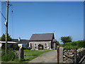
The converted vestry of Capel Bethel
Capel Bethel, a Welsh Baptist chapel, complete with a chapel house, was built in 1861, replacing an earlier chapel of 1841. A vestry was added in 1932. In 1992 both chapel and chapel house were demolished and services were there after held in the vestry. In 2003, the vestry was sold and converted into a house.
Image: © Eric Jones
Taken: 29 May 2009
0.00 miles
5
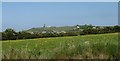
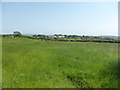
View across a flowery meadow towards Mynydd Parys mountain
Image: © Eric Jones
Taken: 29 May 2009
0.11 miles
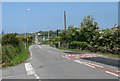
6
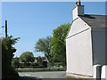
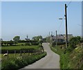
The junction of Lon Gwynfryn and Lon Gefn
The gable belongs to Gwynfryn, the house that gave its name to the lane. The cottage opposite is Hen-Rhos-y-bol.
Image: © Eric Jones
Taken: 29 May 2009
0.11 miles
7
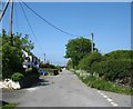
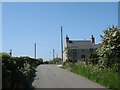
View north along the back road at Rhosybol
Rhosybol consists essentially of two parallel streets connected by link roads. The main buildings, school, church, pub, shops etc are on the B5111. Many of the buildings on the back road (lon gefn) are small holdings dating from the days of the copper miner-farmers.
Image: © Eric Jones
Taken: 29 May 2009
0.11 miles
8
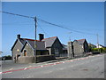
Ysgol Gymuned Rhosybol Community School
http://www.rhosybol.anglesey.sch.uk/
Image: © Eric Jones
Taken: 29 May 2009
0.12 miles
9
The junction of Lon Gwynfryn and the B5111
Image: © Eric Jones
Taken: 29 May 2009
0.12 miles
10
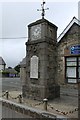
War memorial and clock tower, Rhosybol
In the grounds of Ysgol Gymuned Rhosybol / Rhosybol Primary School.
The memorial is unusual in that it only shows the names of those who fell in the First World War and not those in the Second.
The Inscription reads
"Great War 1914-1918. This memorial was erected to remember the heroes of this parish who gave their lives in sacrifice for their country, justice and freedom".
Image: © Richard Hoare
Taken: 4 Jul 2016
0.14 miles