IMAGES TAKEN NEAR TO
Pentrefelin, AMLWCH, LL68 9PF
Introduction
This page details the photographs taken nearby to LL68 9PF by members of the Geograph project.
The Geograph project started in 2005 with the aim of publishing, organising and preserving representative images for every square kilometre of Great Britain, Ireland and the Isle of Man.

There are currently over 7.5m images from over14,400 individuals and you can help contribute to the project by visiting https://www.geograph.org.uk
Image Map
Images are licensed for reuse under creativecommons.org/licenses/by-sa/2.0
Notes
- Clicking on the map will re-center to the selected point.
- The higher the marker number, the further away the image location is from the centre of the postcode.
Image Listing (14 Images Found)
Images are licensed for reuse under creativecommons.org/licenses/by-sa/2.0
Image
Details
Distance
1
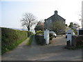
Footpath to Afon Goch
A view looking to the southeast along the public footpath to the Afon Goch. The dwelling at the right is Seren Mon.
Image: © Phil Williams
Taken: 14 Apr 2007
0.03 miles

3
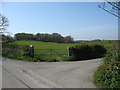
Road junction with the woodland at Tyddyn Dai in the background
Image: © Eric Jones
Taken: 20 Apr 2009
0.17 miles
4

Wet grazing land south of the Pentrefelin road
Image: © Eric Jones
Taken: 20 Apr 2009
0.17 miles
5

The derelict Bodgadfa farmhouse from the west
Image: © Eric Jones
Taken: 20 Apr 2009
0.18 miles
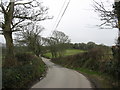
6

Approaching the road junction
The road ahead is a No Through Road leading, eventually, to Parys Farm.
Image: © Eric Jones
Taken: 20 Apr 2009
0.18 miles
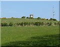
8

Approaching the derelict Bodgadfa Farm
The farmhouse is located on hill slope with the farm buildings on the opposite side of the road. This Bodgadfa should not be confused with the larger neighbouring farmhouse of the same name.
Image: © Eric Jones
Taken: 20 Apr 2009
0.20 miles

10
Pasture land south of the covered reservoir
Image: © Eric Jones
Taken: 20 Apr 2009
0.24 miles