IMAGES TAKEN NEAR TO
Amlwch Port, AMLWCH, LL68 9LL
Introduction
This page details the photographs taken nearby to LL68 9LL by members of the Geograph project.
The Geograph project started in 2005 with the aim of publishing, organising and preserving representative images for every square kilometre of Great Britain, Ireland and the Isle of Man.

There are currently over 7.5m images from over14,400 individuals and you can help contribute to the project by visiting https://www.geograph.org.uk
Image Map
Images are licensed for reuse under creativecommons.org/licenses/by-sa/2.0
Notes
- Clicking on the map will re-center to the selected point.
- The higher the marker number, the further away the image location is from the centre of the postcode.
Image Listing (10 Images Found)
Images are licensed for reuse under creativecommons.org/licenses/by-sa/2.0
Image
Details
Distance
1
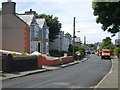
Chapel Street, Amlwch Port
This a view westwards towards Amlwch along Chapel Street, which is an extension of Llaneilian Road.
Image: © Eric Jones
Taken: 20 Jul 2009
0.18 miles
2
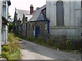
The vestry of the former Capel Carmel, Amlwch Port
Image: © Eric Jones
Taken: 20 Jul 2009
0.18 miles
3
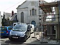
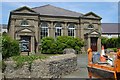
Capel Carmel, Amlwch Port
This former Independent chapel, registered as Grade II building, dates back to 1827, with later additions in 1862. It was sold in 2001. The building on the left hand side was the vestry.
Image: © Eric Jones
Taken: 20 Jul 2009
0.18 miles
4
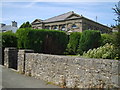
Peniel Welsh Presbyterian Church
A classical facade for this most elegant church situated on the Llaneilian road near to the edge of Amlwch Port.
Image: © Jonathan Wilkins
Taken: 3 Oct 2008
0.20 miles
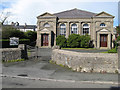
5
Capel Peniel, Amlwch Port
This Calvinist chapel, a Grade II registered building, dates from 1899. It was the third chapel on the site, the earlier ones being built in 1849 and 1861. The architect was Richard Davies of Bangor. The building cost £2,600. It remains open.
Image: © Eric Jones
Taken: 20 Jul 2009
0.20 miles
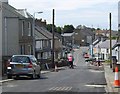
6
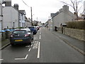
Llaneilian Road in Amlwch Port
Looking westward.
Image: © Peter Wood
Taken: 3 Dec 2017
0.20 miles
7
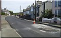
View East along Llaneilian Road, Amlwch Port
Image: © Eric Jones
Taken: 20 Jul 2009
0.21 miles
9
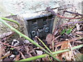
Ordnance Survey Flush Bracket G4963
This partially buried bracket can be found on the wall of the now disused Peniel Chapel at Port Amlwch. The benchmark height is recorded as being 24.825 metres above sea level. For more detail see : http://www.bench-marks.org.uk/bm16374
Image: © Peter Wood
Taken: 3 Dec 2017
0.22 miles
10
The western end of Chapel Street, Amlwch Port
Image: © Eric Jones
Taken: 20 Jul 2009
0.24 miles