IMAGES TAKEN NEAR TO
Llanfechell, AMLWCH, LL68 0UD
Introduction
This page details the photographs taken nearby to LL68 0UD by members of the Geograph project.
The Geograph project started in 2005 with the aim of publishing, organising and preserving representative images for every square kilometre of Great Britain, Ireland and the Isle of Man.

There are currently over 7.5m images from over14,400 individuals and you can help contribute to the project by visiting https://www.geograph.org.uk
Image Map
Images are licensed for reuse under creativecommons.org/licenses/by-sa/2.0
Notes
- Clicking on the map will re-center to the selected point.
- The higher the marker number, the further away the image location is from the centre of the postcode.
Image Listing (15 Images Found)
Images are licensed for reuse under creativecommons.org/licenses/by-sa/2.0
Image
Details
Distance
1
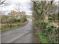
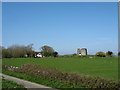
Lane from Tyn Cae to the A5025
Looking eastward.
Image: © Peter Wood
Taken: 8 Dec 2017
0.03 miles
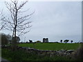
2
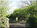
Roofless ruin of the Cefn Coch Woollen Mill
Image: © Eric Jones
Taken: 18 Apr 2009
0.06 miles
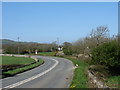
3
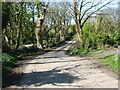
The link road between the A5025 and the Llanfairynghornwy-Cemlyn road
The view westwards is taken from near the disused windmill.
Image: © Eric Jones
Taken: 18 Apr 2009
0.07 miles
4
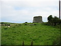
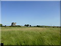
The old and the (fairly) new
A long-disused windmill is prominent. To the left, and peeping over the horizon, is the top of the Wylfa Nuclear Power Station, finally decommissioned at the end of 2015.
Image: © David Purchase
Taken: 25 Jul 2017
0.08 miles
5
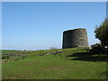
Ty'n y Felin and the remains of the old wind mill
Ty'n y Felin means "mill homestead".
The number of disused/converted mills - wind and water powered - dotted around North Anglesey, an area today where pastoral farming predominates indicates a change in the farming pattern since the 19thC.
Image: © Eric Jones
Taken: 18 Apr 2009
0.08 miles
6
Disused old windmill
There are quite a few of these dotted around the island.
Image: © Jeremy Bolwell
Taken: 4 May 2015
0.08 miles
7
Sweeping bend on the A5025 at Glan Rhyd
The minor road on the right leads to the Llanfairynghornwy-Cemlyn road.
Image: © Eric Jones
Taken: 18 Apr 2009
0.08 miles
9
Hayfield and old mill
Near Caerdegog.
Image: © David Medcalf
Taken: 24 Jul 2014
0.10 miles
10
Two forms of technology - wind and nuclear
The top of the Wylfa reactor can be seen beyond the disused windmill peeping over the skyline. Wylfa is soon to be decommissioned and there are doubt as to whether a replacement station will be built. Meanwhile the modern version of wind power technology has taken firm hold in North Anglesey.
Image: © Eric Jones
Taken: 18 Apr 2009
0.10 miles