IMAGES TAKEN NEAR TO
Carreglefn, AMLWCH, LL68 0PH
Introduction
This page details the photographs taken nearby to LL68 0PH by members of the Geograph project.
The Geograph project started in 2005 with the aim of publishing, organising and preserving representative images for every square kilometre of Great Britain, Ireland and the Isle of Man.

There are currently over 7.5m images from over14,400 individuals and you can help contribute to the project by visiting https://www.geograph.org.uk
Image Map
Images are licensed for reuse under creativecommons.org/licenses/by-sa/2.0
Notes
- Clicking on the map will re-center to the selected point.
- The higher the marker number, the further away the image location is from the centre of the postcode.
Image Listing (36 Images Found)
Images are licensed for reuse under creativecommons.org/licenses/by-sa/2.0
Image
Details
Distance
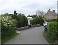
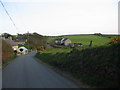
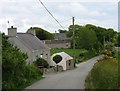
2
The southern section of the main village street of Carreglefn
Image: © Eric Jones
Taken: 23 May 2009
0.02 miles
3
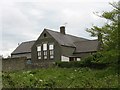
Ysgol Gymuned Carreglefn Community School from the north
Image: © Eric Jones
Taken: 23 May 2009
0.05 miles
4
Ysgol Gymuned Carreglefn Community School
This small school has around 35 pupils, some 75% of which have Welsh as their first language. The school building was constructed by the Anglesey Trading Company jointly owned by Owen Thomas (later Brig-Gen Owen Thomas) a local farmer and businessman using bricks from his Cemaes brickworks Image
http://www.garreglefn.anglesey.sch.uk/
Image
Image: © Eric Jones
Taken: 23 May 2009
0.05 miles
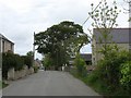
5
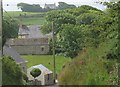
Treiolfa
A view looking south along the lane from Carreglefn towards the buildings of Treiolfa.
Image: © Phil Williams
Taken: 19 Apr 2006
0.06 miles
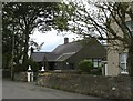
6
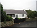
The Forge
A family home from the Fifties. Happy memories
Image: © Keith Leyland
Taken: 31 Aug 2009
0.06 miles
7
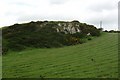
A rock outcrop above Pant y Coli
The land surrounding the outcrop has been improved to provide cultivated grassland.
Image: © Eric Jones
Taken: 23 May 2009
0.07 miles
8
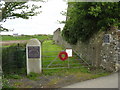
Entrance to the Carreglefn & District War Memorial Playing Field
Image: © Eric Jones
Taken: 23 May 2009
0.07 miles
9
Pant-y-coli, Treiolfa and Bryn Pabo - three houses on the south side of Carreglefn
Image: © Eric Jones
Taken: 13 Jun 2009
0.10 miles
10
Pant-y-coli cottage, Carreglefn
In the late 18thC Pant-y-coli cottage was a meeting place for the Calvinists.
The little lane on the north side of the cottage leads to Tan-y-bryn.
Image: © Eric Jones
Taken: 23 May 2009
0.10 miles