IMAGES TAKEN NEAR TO
CEMAES BAY, LL67 0HB
Introduction
This page details the photographs taken nearby to LL67 0HB by members of the Geograph project.
The Geograph project started in 2005 with the aim of publishing, organising and preserving representative images for every square kilometre of Great Britain, Ireland and the Isle of Man.

There are currently over 7.5m images from over14,400 individuals and you can help contribute to the project by visiting https://www.geograph.org.uk
Image Map
Images are licensed for reuse under creativecommons.org/licenses/by-sa/2.0
Notes
- Clicking on the map will re-center to the selected point.
- The higher the marker number, the further away the image location is from the centre of the postcode.
Image Listing (151 Images Found)
Images are licensed for reuse under creativecommons.org/licenses/by-sa/2.0
Image
Details
Distance
1
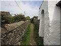
Alleyway
The route of The Isle of Anglesey Coastal Path.
Image: © Chris McAuley
Taken: 1 Aug 2013
0.01 miles

3
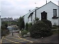
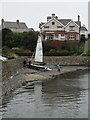
Cottages by the Harbour at Cemaes
Image: © Sarah Charlesworth
Taken: 9 Jul 2006
0.03 miles
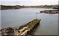
6
By the sea at Penrhyn on a Sunday morning
Image: © Neil Theasby
Taken: 9 Apr 2017
0.05 miles
7

Ysgoldy Penrhyn
This is a former Calvinist chapel. The building dates from 1899, when it replaced a building of 1786.
Image: © Eric Jones
Taken: 9 Jan 2009
0.05 miles
8
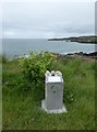
GeoMon Information Point on Trwyn y Penrhyn
Information and examples of rocks found in this area.
Image: © Eirian Evans
Taken: 19 Jun 2015
0.05 miles
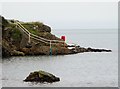
10
Harry Furlong (Harry Furlough) Buoy
This is an old Trinity House buoy formerly used to mark Harry Furlong's Rocks (Harry Furlough on the OS map) at Cemlyn Bay. A local character named 'Harris' is reputed to have extinguished beacon lights that marked the rocks at Cemlyn, thus wrecking them on the rocks. The rocks were a furlong distance from the shore. Over time the name is supposed to have changed to Harry Furlough (Furlong) Rocks. The stone beacon was changed to a green conical buoy in the late 1960's. [SH3394]
Image: © Andrew Fielding
Taken: 6 Jun 2010
0.06 miles