IMAGES TAKEN NEAR TO
Gwalchmai, HOLYHEAD, LL65 4RD
Introduction
This page details the photographs taken nearby to LL65 4RD by members of the Geograph project.
The Geograph project started in 2005 with the aim of publishing, organising and preserving representative images for every square kilometre of Great Britain, Ireland and the Isle of Man.

There are currently over 7.5m images from over14,400 individuals and you can help contribute to the project by visiting https://www.geograph.org.uk
Image Map
Images are licensed for reuse under creativecommons.org/licenses/by-sa/2.0
Notes
- Clicking on the map will re-center to the selected point.
- The higher the marker number, the further away the image location is from the centre of the postcode.
Image Listing (32 Images Found)
Images are licensed for reuse under creativecommons.org/licenses/by-sa/2.0
Image
Details
Distance
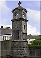
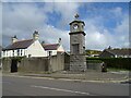
2
War Memorial clock at Gwalchmai Crossroads
Image: © Eric Jones
Taken: 28 Jun 2008
0.04 miles
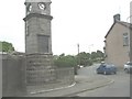
5
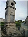
Gwalchmai War Memorial
Taken from the old A5 road.
Image: © Clint Mann
Taken: 29 Sep 2014
0.04 miles
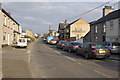
6
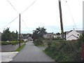
Houses along Allt Fawr
This road descends down to the main street (Holyhead Road - A5).
Image: © Eric Jones
Taken: 12 Jul 2008
0.05 miles
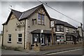
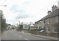
9
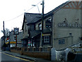
Gwalchmai
Gwalchmai is a quieter place since the A55 took most of the traffic off the A5, which passes through the village. The Gwalchmai Hotel is on the right.
Image: © Stephen McKay
Taken: 30 Mar 2013
0.06 miles