IMAGES TAKEN NEAR TO
Llanddeusant, HOLYHEAD, LL65 4DS
Introduction
This page details the photographs taken nearby to LL65 4DS by members of the Geograph project.
The Geograph project started in 2005 with the aim of publishing, organising and preserving representative images for every square kilometre of Great Britain, Ireland and the Isle of Man.

There are currently over 7.5m images from over14,400 individuals and you can help contribute to the project by visiting https://www.geograph.org.uk
Image Map
Images are licensed for reuse under creativecommons.org/licenses/by-sa/2.0
Notes
- Clicking on the map will re-center to the selected point.
- The higher the marker number, the further away the image location is from the centre of the postcode.
Image Listing (6 Images Found)
Images are licensed for reuse under creativecommons.org/licenses/by-sa/2.0
Image
Details
Distance
1
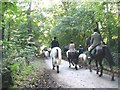
Returning from the hunt near Llynnon Hall
These are members of the Anglesey Drag Hunt which was formed back on the 1970s.
http://www.angleseydraghounds.co.uk/dates.htm
Image: © Eric Jones
Taken: 27 Sep 2008
0.06 miles
2
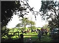
The end of a day's hunting in the Tregwehelydd-Llynnon Hall area
The field in the photo faces Llynnon Hall.
Image: © Eric Jones
Taken: 27 Sep 2008
0.11 miles
3
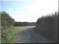
Junction with wider unclassified road north of Graianfryn
Image: © Eric Jones
Taken: 27 Sep 2008
0.15 miles

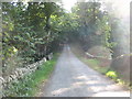
6
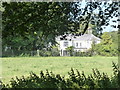
Llynon Hall
The hall has a different spelling of Llynnon.
Image: © David Medcalf
Taken: 24 Jul 2014
0.20 miles