IMAGES TAKEN NEAR TO
Llanfachraeth, HOLYHEAD, LL65 4DD
Introduction
This page details the photographs taken nearby to LL65 4DD by members of the Geograph project.
The Geograph project started in 2005 with the aim of publishing, organising and preserving representative images for every square kilometre of Great Britain, Ireland and the Isle of Man.

There are currently over 7.5m images from over14,400 individuals and you can help contribute to the project by visiting https://www.geograph.org.uk
Image Map
Images are licensed for reuse under creativecommons.org/licenses/by-sa/2.0
Notes
- Clicking on the map will re-center to the selected point.
- The higher the marker number, the further away the image location is from the centre of the postcode.
Image Listing (16 Images Found)
Images are licensed for reuse under creativecommons.org/licenses/by-sa/2.0
Image
Details
Distance
1
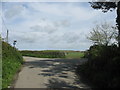
Minor road junction south of Stryd y Facsen on Cycle Route 5
Image: © Eric Jones
Taken: 3 May 2009
0.02 miles
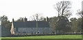
3
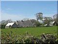
Ger yr Afon Farm
Members of the Anglesey hunt can be seen cantering past the farm on their way back to Tregwehelydd,
Image: © Eric Jones
Taken: 27 Sep 2008
0.10 miles
4
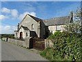
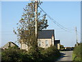
Ty'n-y-Maen Chapel (1904)
An isolated rural chapel and connected house at a T junction north of Llanfigael. It replaced an earlier chapel built near the beginning of the nineteenth century.
Image: © Neil Theasby
Taken: 10 Apr 2017
0.11 miles
5
Ty'n y Maen Farmhouse, Stryd y Facsen
This a delightful example of a traditional Anglesey farmhouse.
Image: © Eric Jones
Taken: 3 May 2009
0.11 miles
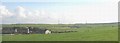
6
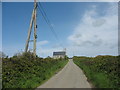
View north towards Ty'n y Maen Chapel
A local GP out on his rounds, his wife and mother in law, were killed near here when a burning Wellington bomber collided with their car.
Image
Image: © Eric Jones
Taken: 27 Sep 2008
0.11 miles
7
Approaching Capel Ty'n y Maen, Stryd y Facsen
The present chapel dates from 1904.
Image: © Eric Jones
Taken: 3 May 2009
0.11 miles
8
Ty'n y Maen
A view looking to the northwest across a road junction to the chapel at Ty'n y Maen.
Image: © Phil Williams
Taken: 18 Apr 2006
0.12 miles
9
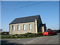
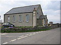
Capel Ty'n y Maen
This Calvinistic Methodist chapel stands at a minor road junction. The present chapel, which is still open, was built in 1904 on the site of an earlier chapel. That, much smaller chapel, was built in 1800 and was one of the earliest Calvinist chapels in Anglesey.
Image: © Eric Jones
Taken: 27 Sep 2008
0.12 miles
10
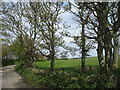
The field where the Vickers Wellington DV455 crashed before skewing on to the road and hitting a car
The accident happened at 14.25 on the afternoon of Monday, 19, July, 1943 and cost the lives of the local GP, his wife and mother-in-law. By sheer coincidence, a Vampire T11 jet from RAF Valley crashed in the same field on the 24th of April, 1961, fortunately with no loss of life.
Image
Image: © Eric Jones
Taken: 3 May 2009
0.14 miles