IMAGES TAKEN NEAR TO
Llanddeusant, HOLYHEAD, LL65 4AD
Introduction
This page details the photographs taken nearby to LL65 4AD by members of the Geograph project.
The Geograph project started in 2005 with the aim of publishing, organising and preserving representative images for every square kilometre of Great Britain, Ireland and the Isle of Man.

There are currently over 7.5m images from over14,400 individuals and you can help contribute to the project by visiting https://www.geograph.org.uk
Image Map
Images are licensed for reuse under creativecommons.org/licenses/by-sa/2.0
Notes
- Clicking on the map will re-center to the selected point.
- The higher the marker number, the further away the image location is from the centre of the postcode.
Image Listing (32 Images Found)
Images are licensed for reuse under creativecommons.org/licenses/by-sa/2.0
Image
Details
Distance
1
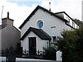
Ysgoldy Pisgah - a converted Sunday Schoolroom
This was a Sunday schoolroom of Capel Elim Image It was sold in 1968 and converted into a bungalow.
Image: © Eric Jones
Taken: 27 Sep 2008
0.01 miles
2
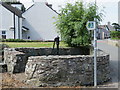
Llanddeusant water pump
This old cast iron water pump stands in its own enclosure alongside the main road through the village of Llanddeusant, Anglesey. For a close up see Image
Image: © John S Turner
Taken: 19 Jun 2017
0.01 miles
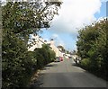
3
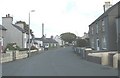
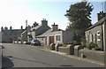
The village street of Llanddeusant
This a view north-eastwards in the direction of the (hidden) parish church.
Image: © Eric Jones
Taken: 27 Sep 2008
0.01 miles
4
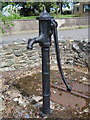
Llanddeusant water pump 2
A close up of the old cast iron water pump that stands in its own enclosure alongside the main road through Llanddeusant, Anglesey. See also Image
Image: © John S Turner
Taken: 19 Jun 2017
0.02 miles
6
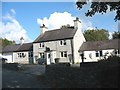
Ty'n Llan, Llanddeusant
In the past Ty'n Llan (=homestead within the religious enclosure) was a public house part of the income of which went to the church. The house stands about 100m from the church.
Image: © Eric Jones
Taken: 27 Sep 2008
0.03 miles
7
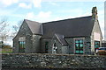
Ysgol Gynradd Llanddeusant Primary School
Built in 1847, this small village school opposite the church is, like so many others, under threat of closure.
Image: © Alan Fryer
Taken: 19 Mar 2008
0.07 miles
8

The door of SS Marcellus and Marcellinus, Llanddeusant
The door into the tower of the church of SS Marcellus and Marcellinus, Llanddeusant, Isle of Anglesey.
Image: © John S Turner
Taken: 17 Jun 2017
0.08 miles
9
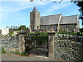
The church of SS Marcellus and Marcellinus, Llanddeusant
The church of SS Marcellus and Marcellinus, Llanddeusant, Isle of Anglesey from the main road through the village. There is an Ordnance Survey bench mark on the east facing gable end of the church - Image
Image: © John S Turner
Taken: 19 Jun 2017
0.08 miles
10
The southern end of Llanddeusant village
Image: © Eric Jones
Taken: 27 Sep 2008
0.08 miles