
IMAGES TAKEN NEAR TO
Caergeiliog, HOLYHEAD, LL65 3YF
Introduction
This page details the photographs taken nearby to LL65 3YF by members of the Geograph project.
The Geograph project started in 2005 with the aim of publishing, organising and preserving representative images for every square kilometre of Great Britain, Ireland and the Isle of Man.

There are currently over 7.5m images from over14,400 individuals and you can help contribute to the project by visiting https://www.geograph.org.uk
Image Map
Images are licensed for reuse under creativecommons.org/licenses/by-sa/2.0
Notes
- Clicking on the map will re-center to the selected point.
- The higher the marker number, the further away the image location is from the centre of the postcode.
Image Listing (16 Images Found)
Images are licensed for reuse under creativecommons.org/licenses/by-sa/2.0
Image
Details
Distance
1
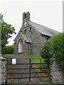
Eglwys Dewi Sant/St David's Church, Caergeiliog
This church dates only from the 1910s and is built in what is described as "Arts and Crafts style". Situated just within the boundary of the Bodedern parish, it was built as a mission hall.
Image: © Eric Jones
Taken: 28 Jun 2008
0.02 miles
2
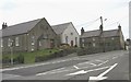
Y Neuadd and Capel Caergeiliog (MC)
Y Neuadd (=the hall) is the village hall built in 1930 at a cost of £2000. Next door is Capel Caergeiliog - a Calvinistic Methodist chapel - dating from 1872.
Image: © Eric Jones
Taken: 28 Jun 2008
0.03 miles
3
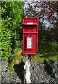
Elizabeth II postbox on Holyhead Road, Caergeiliog
Postbox No. LL65 47.
Image: © JThomas
Taken: 16 Apr 2024
0.04 miles
4
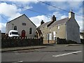
Ty Capel, Caergeiliog
Chapel and adjoining chapel house currently for sale.
Grade II listed.
Image: © JThomas
Taken: 16 Apr 2024
0.05 miles
5
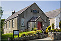
WWII Defences of North Wales: RAF Valley - Operations Block (1)
-
Caergeiliog Chapel Hall: temporary wartime Operations Room
During the Second World War RAF Valley operated as a fighter station for No. 9 Group defending England's industrial north-west and shipping in the Irish Sea. Operations against the enemy were planned and directed initially from this temporary Operations Room at the nearby village of Caergeiliog's chapel hall. A purpose-built Operations Block would be built later, the chapel hall having to suffice until such time as it became operational.
Image
Image: © Mike Searle
Taken: 4 Aug 2021
0.06 miles
6
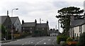
Caergeiliog, Anglesey.
The view entering the village of Caergeiliog from the east.
Image: © Stephen Elwyn RODDICK
Taken: 1 Aug 2006
0.06 miles
7
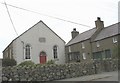
Capel Caergeiliog and Chapel House
Capel Caergeiliog is a Calvinistic Methodist chapel. The chapel was first built in 1786 and then rebuilt almost a century later, in 1872 preserving the old Georgian facade. The house adjoining the chapel is Ty Capel - the chapel house.
Image: © Eric Jones
Taken: 28 Jun 2008
0.07 miles
8
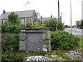
The Memorial to Mathew Williams (Mathew Bach) a Country Poet
Image: © Eric Jones
Taken: 28 Jun 2008
0.07 miles
9
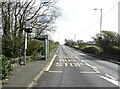
Bus stop and shelter on Ffordd Caergybi (Holyhead Road), Caergeiliog
Image: © JThomas
Taken: 16 Apr 2024
0.09 miles
10
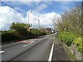
Ffordd Caergybi (Holyhead Road), Caergeiliog
Image: © JThomas
Taken: 16 Apr 2024
0.09 miles