IMAGES TAKEN NEAR TO
Bodedern, HOLYHEAD, LL65 3UN
Introduction
This page details the photographs taken nearby to LL65 3UN by members of the Geograph project.
The Geograph project started in 2005 with the aim of publishing, organising and preserving representative images for every square kilometre of Great Britain, Ireland and the Isle of Man.

There are currently over 7.5m images from over14,400 individuals and you can help contribute to the project by visiting https://www.geograph.org.uk
Image Map
Images are licensed for reuse under creativecommons.org/licenses/by-sa/2.0
Notes
- Clicking on the map will re-center to the selected point.
- The higher the marker number, the further away the image location is from the centre of the postcode.
Image Listing (6 Images Found)
Images are licensed for reuse under creativecommons.org/licenses/by-sa/2.0
Image
Details
Distance
1

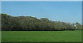
Modern farm building and sheep pastures at Ty'n-y-pant Farm
Image: © Eric Jones
Taken: 14 Apr 2008
0.12 miles
3
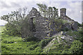
Remains of cottage at Trefor, Bodedern
On same site as Felin Mannau Floor Mill.
Image: © Arthur C Harris
Taken: 15 May 2016
0.20 miles
4
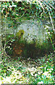
Old Milestone by the B5109, east of Bodedern
Stone post by the B5109, in parish of Bodffordd (Anglesey District), East Ty'n-y-Pant and Cae Wian, in embankment.
Inscription once read:-
(Holyhead)
(10)
Surveyed
Milestone Society National ID: ANG_OHH10
Image: © Milestone Society
Taken: Unknown
0.21 miles
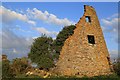
5
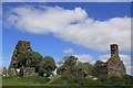
Felin Mannau Mill
The remains of Felin Mannau Floor Mill and Cottage, Anglesey.
Image: © Arthur C Harris
Taken: 15 May 2016
0.21 miles
6
Felin Mannau Flour Mill, Anglesey
The remains of Felin Mannau Flour Mill, Isle of Anglesey.
Image: © Arthur C Harris
Taken: 15 May 2016
0.22 miles